Prof. Dr.-Ing. Danilo Schneider
Inhaltsverzeichnis
Diese Seite wird nicht mehr aktualisiert. Aktuelle/weitere Informationen finden Sie auf der Webseite der HTW Dresden.
 © IPF
© IPF
Wiss. Mitarbeiter
NameHerr Dr.-Ing. Danilo Schneider
Eine verschlüsselte E-Mail über das SecureMail-Portal versenden (nur für TUD-externe Personen).
Lebenslauf
- 1997-2002 Geodäsie-Studium an der TU Dresden
- 2001 Auslandspraktikum an der University of Newcastle (Großbritannien)
- Studentische Hilfkraft an der TU Dresden, Institut für Hydrologie, Institut für Geodäsie (Professur Geodäsie und Professur Ingenieurgeodäsie) und Institut für Photogrammetrie und Fernerkundung
- 2002 Diplomarbeit (Sensormodellierung zur photogrammetrischen Nutzung einer Panoramakamera)
- seit 2003 Wissenschaftlicher Mitarbeiter am Institut für Photogrammetrie und Fernerkundung
- 2004 - 2008 Sekretär der Commission V der ISPRS
- 2008 Promotion zum Thema "Geometrische und stochastische Modelle für die integrierte Auswertung photogrammetrischer Bilddaten und terrestrischer Laserscannerdaten"
- 2011 - 2015 Stellvertretender Leiter des Arbeitskreises "Optische 3D-Messtechnik" der DGPF
- 2012 - 2016 Co-Chair der Working Group V/3 der ISPRS (Terrestrial Laser Scanning)
- seit 2016 Leiter des Arbeitskreises "Optische 3D-Messtechnik" der DGPF
- seit 2016 International Editorial Board Member (IEBM) des Photogrammetric Record
- seit 2018 International Editorial Board Coordinator des Photogrammetric Record
- seit 1.3.2022 Professor für Photogrammetrie an der HTW Dresden
Auszeichnungen
Lehre
- Vorlesungsreihe "Grundlagen der Photogrammetrie"
- Themenvorlesungen in den Modulen "Optische 3D-Messtechnik" und "Laserscanning/Punktwolkenverarbeitung"
- Betreuung vorlesungsbegleitender Übungen
- Betreuung und Koordinaten studentischer Praxisprojekte zum Thema "Terrestrisches Laserscanning und Punktwolkenverarbeitung"
- Betreuung und Koordination studentischer Programmierprojekte "Photogrammetrie im Autonomen Fahren" (C++/ROS) und "Objekterkennung und Geodatenfusion" (C++/PCL)
- Betreuung der Informatik-Studenten im Nebenfach Photogrammetrie
- Betreuung von Bachelor- und Masterarbeiten sowie anderen Projektarbeiten im Fach Photogrammetrie
Weitere Aufgaben
- Photogrammetrische Deformationsanalysen und Kalibrierung von Kameras
- Schwerpunkte: Nahbereichsphotogrammetrie und optische 3D-Messtechnik, Terrestrisches Laserscanning
- Forschungsarbeiten im Bereich Sensormodellierung und Sensorintegration
(zentralperspektive Kamera, Panoramakameras, Fisheye-Objektive, Terrestrische Laserscanner) - Gutachtertätigkeit für verschiedene Zeitschriften (PFG, Photogrammetric Record, ISPRS Journal of Photogrammetry and Remote Sensing, etc.)
- Mitglied der Studienkommission Geodäsie und AG Studierendenmarketing der Fachrichtung Geowissenschaften
- Organisation und Durchführung von Projekten mit terrestrischen Laserscannern
- Gestaltung und Betreuung der Webseiten der Professur
Publikationen
Erweiterte Recherchemöglichkeiten (z.B. Suche nach Schlagworten) sind im Forschungsinformationssystem der TU Dresden möglich.
- Digitale Nahbereichsphotogrammetrie/Optische 3D Messverfahren
- Eltner, A., Schneider, D. (2015):
Analysis of Different Methods for 3D Reconstruction of Natural Surfaces from Parallel-Axes UAV Images. The Photogrammetric Record, 30(151), p. 279-299, (Link Wiley). - Hecht, A., Schneider, D. (2015):
Machbarkeitsstudie zur 3D-Erfassung und Auswertung von medikamentös induzierter „Gänsehaut“ - Mit Kurzvortrag. 35. Wissenschaftlich-Technische Jahrestagung der DGPF e.V. und Workshop on Laser Scanning Applications, Köln (DGPF Tagungsband 24 / 2015). (DGPF, 1,41 MB) - Kraft, A., Schneider, D., Maas, H.-G., Rüdiger, M., Ifflaender, S. (2015):
Untersuchungen zur Eignung photogrammetrischer Methoden zur Bestimmung von Schädelvolumen und Schädeldeformitäten Frühgeborener. Photogrammetrie - Laserscanning - Optische 3D-Messtechnik, Beiträge der Oldenburger 3D-Tage 2015, Hrsg. Th. Luhmann, Verlag Herbert Wichmann. (203 kB)
- Blaskow, R., Schneider, D. (2014):
Analsysis and correction of the dependency between laser scanner intensity and range. Int. Arch. Photogramm. Remote Sens. Spatial Inf. Sci., XL-5, 107-112, doi:10.5194/isprsarchives-XL-5-107-2014, 2014. (presented on the ISPRS TC V Symposium in Riva del Garda, Italy Link to ISPRS Archives) - Schneider, D., Leonhardt, M., Frevert, V. (2014):
Untersuchungen zur GNSS-gestützten globalen Registrierung von Punktwolken terrestrischer Laserscanner. Gemeinsame Tagung 2014 der DGfK, der DGPF, der GfGI und des GiN, Hamburg (DGPF Tagungsband 23/2014). (590 kB) - Sima, A., Buckley, S.J., Kurz T.H., Schneider, D. (2014):
Semi-Automated Registration Of Close-Range Hyperspectral Scans Using Oriented Digital Camera Imagery And A 3d Model. The Photogrammetric Record 03/2014, Vol. 28 Issue 144. (DOI: 10.1111/phor.12049)
- Buckley, S., Kurz, T., Howell, J., Schneider, D. (2013):
Terrestrial lidar and hyperspectral data fusion products for geological outcrop analysis. Journal for Computers & Geosciences, Volume 54, April 2013, p. 249-258. (Link to ScienceDirect ) - Maas, H.-G., Casassa, G., Schneider, D., Schwalbe, E., Wendt, A. (2013):
Photogrammetric Techniques for the Determination of Spatio-temporal Velocity Fields at Glaciar San Rafael, Chile. Photogrammetric Engineering and Remote Sensing, Vol. 79, No. 3, pp. 299-306, (Link to ASPRS Online)
- Richter, K., Seidl, K., Schneider, D., Mader, D., Maas, H.-G. (2012):
Entwicklung eines geometrischen Modells für ein voll-reflektives Kamerasystem für Nahbereichanwendungen. 32. Jahretagung der Deutschen Gesellschaft für Photogrammetrie, Fernerkundung und Geoinformation in Potsdam, DGPF Tagungsband 21/2012. (660 kB) - Sima, A., Buckley, S.J., Kurz, T.H., Schneider, D. (2012):
Semi-automatic Integration of Panoramic Hyperspectral Imagery with Photorealistic Lidar Models. Photogrammetrie - Fernerkundung - Geoinformation. Organ der DGPF. Schweizerbart'sche Verlagsbuchhandlung. Jahrgang 2012, Heft 4, S. 443-454. (PFG 04/2012)
- Kurz, T., Buckley, S., Howell, J., Schneider, D. (2011):
Integration of panoramic hyperspectral imaging with terrestrial lidar data. The Photogrammetric Record. Volume 26, Issue 134, pp. 212-228. (Link: Wiley - Online Library)
Publikationen 2010
- Schneider, D. (2010):
Integrierte Bündelblockausgleichung terrestrischer Laserscannerdaten und photogrammetrischer Bilddaten. Beiträge zum 101. DVW-Seminar 'Terrestrisches Laserscanning'. Schriftenreihe des DVW, Band 64, S. 181-194. - Maas, H.-G., Schneider, D., Schwalbe, E., Casassa, G., Wendt, A. (2010):
Photogrammetric techniques for the determination of spatio-temporal velocity fields at Glaciar San Rafael in the Northern Patagonian Icefield. International Archives of Photogrammetry, Remote Sensing and Spatial Information Sciences, Vol. 38, Part 5. - Maas, H.-G., Schneider, D., Schwalbe, E., Casassa, G., Wendt, A. (2010):
Photogrammetric determination of spatio-temporal velocity fields at Glaciar San Rafael. International Glaciological Conference VICC 2010 "Ice and Climate Change: A View from the South", Valdivia, Chile, 1-3 February 2010. Abstract Book, 72(88), CECS, Valdivia, Chile. - Seidl, K., Knobbe, J., Schneider, D., Lakner, H. (2010):
Distortion correction of all-reflective unobscured optical-power zoom objective. APPLIED OPTICS, Vol. 49, No. 14, 10 May 2010.
Publikationen 2009
- Schneider, D.; Schwalbe, E.; Maas, H.-G. (2009):
Validation of geometric models for fisheye lenses. ISPRS Journal of Photogrammetry and Remote Sensing (Link: Science Direct) - Schneider, D.; Urbansky, D.; Maas, H.-G. (2009):
Vision Teachlets - Web-based visualisation of algorithms in photogrammetry and image analysis. Proceedings ISPRS Workshop on E-Learning Tools, Techniques and Applications, Potsdam, Germany. (900 KB) - Schneider, D. (2009):
Calibration of a Riegl LMS-Z420i based on a multi-station adjustment and a geometric model with additional parameters. Proceedings ISPRS Workshop on Laserscanning, Paris, France. - Kurz, T.; Buckley, S.; Howell, J.; Schneider, D. (2009):
Close range hyperspectral and lidar data integration for geological outcrop analysis. Proceedings WHISPERS, Workshop on Hyperspectral Image and Signal Processing, Grenoble, France. - Schneider, D. (2009):
Geometrische und stochastische Modelle für die integrierte Auswertung terrestrischer Laserscannerdaten und photogrammetrischer Bilddaten. Dissertation Institut für Photogrammetrie und Fernerkundung. ISBN 978-3-7696-5054-9. (Deutsche Geodätische Kommission)
Publikationen 2008
- Schneider, D.; Schwalbe, E. (2008):
Integrated processing of terrestrial laser scanner data and fisheye-camera image data. Paper presented at the XXIth Congress of the ISPRS in Beijing. International Archives of Photogrammetry, Remote Sensing and Spatial Information Science, Volume XXXVII. - Kurz, T.; Buckley, S.; Howell, J.; Schneider, D. (2008):
Geological outcrop modelling and interpretation using ground based hyperspectral and laser scanning data fusion. Paper presented at the XXIth Congress of the ISPRS in Beijing. International Archives of Photogrammetry, Remote Sensing and Spatial Information Science, Volume XXXVII.
Publikationen 2007
- Schneider, D.; Maas, H.-G. (2007):
Integrated Bundle Adjustment of Terrestrial Laser Scanner Data and Image Data with Variance Component Estimation. The Photogrammetric Journal of Finland, Volume 20/2007, pp. 5 - 15. - Maas, H.-G.; Schneider, D. (2007):
Sonderheft der PFG mit Beiträgen des ISPRS - Commission V - Symposiums 2006 in Dresden. Photogrammetrie, Fernerkundung und Geoinformation, Heft 3/07 - Schneider, D. (2007):
Kombinierte Bündelblockausgleichung mit Varianzkomponentenschätzung bei der Fusion terrestrischer Laserscannerdaten, Panorama- und zentralperspektivischer Bilddaten. Publikationen der Deutschen Gesellschaft für Photogrammetrie, Fernerkundung und Geoinformation, 27. DGPF-Jahrestagung Muttenz/Basel (Dreiländertagung), Band 16, S. 465-474 - Schneider, D.; Maas, H.-G. (2007):
Inegrated bundle adjustment with variance component estimation - fusion of terrestrial laser scanner data, panoramic and central perspective image data. Proceedings ISPRS Workshop Laser Scanning and SilviLaser 2007, Espoo (Finnland), International Archives of Photogrammetry, Remote Sensing and Spatial Information Sciences, Vol. XXXVI, Part3/W52
Publikationen 2006
- Maas, H.-G.; Schneider. D. (Eds.)(2006):
Image Engineering and Vision Metrology. Proceedings ISPRS Com. V Symposium, International Archives of Photogrammetry, Remote Sensing and Spatial Information Sciences, Vol. 36, Part 5 (Link) - Schneider, D.; Maas, H.-G. (2006):
A geometric model for linear-array-based terrestrial panoramic cameras. The Photogrammetric Record 21(115), pp. 198-210 (September 2006), Blackwell Publishing Ltd., Oxford, UK. - Seidl, K.; Knobbe, J.; Schneider, D.; Schönherr, H.-J.; Lakner, H. (2006):
Opto-mechanical combination of a line scanning camera and a micro laserscanner system. International Archives of Photogrammetry, Remote Sensing and Spatial Information Sciences, Vol. XXXVI, Part 5. - Schneider, D. (2006):
Terrestrial laserscanning for area based deformation analysis of towers and water dams. Proceedings of 3rd IAG Sympoisum on Geodesy for Geotechnical and Structural Engineering & 12th FIG Symposium on Deformation Measurement, Editors: H. Kahmen, A. Chrzanowksi. Baden (Austria) 2006. - Scheller, S.; Schneider, D. (2006):
Extraktion von Primitiven aus Laserscannerpunktwolken zur Rekonstruktion von Tragwerken. Photogrammetrie - Laserscanning - Optische 3D-Messtechnik (Beiträge Oldenburger 3D-Tage 2006, Hrsg. Th. Luhmann), Verlag Herbert Wichmann.
Publikationen 2005
- Schwalbe, E.; Schneider, D. (2005):
Immersive Photogrammetry. Proceedings zu Konferenz und Workshop für HDR-Fotografie und 3D-Visualisierung. SpheronVR - Advanced digital imaging, Briese Studios Hamburg - Schwalbe, E.; Schneider, D. (2005):
Design and testing of mathematical models for a full-spherical camera on the basis of a rotating linear array sensor and a fisheye lens. Grün, A.; Kahmen H. (Eds.): Optical 3-D Measurement Techniques VII. Vol. I, pp. 245-254, Vienna (Austria) - Schneider, D.; Pötzsch, M.; Maas, H.-G. (2005):
Accuracy and application potential of the 94 megapixel RGB macro-scanning camera Pentacon Scan 5000. Paper presented at CIPA Symposium 2005, Turin (Italy). CIPA Archives for Documentation of Cultural Heritage, Volume XX-2005 & ISPRS International Archives, Volume XXXVI-5/C34 - Henze, F.; Wulf-Rheidt, U.; Schneider, D.; Bienert, A. (2005):
Photogrammetric and geodetic documentation methods at St. Petri Cathedral, Bautzen. Paper presented at CIPA Symposium 2005, Turin (Italy). CIPA Archives for Documentation of Cultural Heritage, Volume XX-2005 & ISPRS International Archives, Volume XXXVI-5/C34 - Schneider, D.; Maas, H.-G. (2005):
Combined bundle adjustment of panoramic and central perspective images. (presented at 2nd Panoramic Photogrammetry Workshop) International archives of Photogrammetry, Remote Sensing and Spatial Information Sciences. Vol. XXXVI, Part 5/W8 - Schneider, D.; Pötzsch, M.; Maas, H.-G. (2005):
Genauigkeits- und Einsatzpotenzial des Macro-Scanning-Systems Pentacon Scan 5000. Luhmann, T. (Hrsg.): Photogrammetrie, Laserscanning, Optische 3D-Messtechnik - Beiträge der Oldenburger 3D-Tage 2005. pp. 82-89, Herbert Wichmann Verlag, Heidelberg - Maas, H.-G.; Schneider, D. (2005): Japan Association of Surveyors (JAS-Online)
Publikationen 2004
- Schneider, D.; Maas, H.-G. (2004):
Development and Application of an Extended Geometric Model for High Resolution Panoramic Cameras. Paper presented at the XXth Congress of the ISPRS in Istanbul International Archives of Photogrammetry, Remote Sensing and Spatial Information Science. Vol XXXV, Part B - Maas, H.-G.; Schneider, D. (2004):
Photogrammetric Processing of 360� Panoramic Images - Geometric Modelling of the EyeScan M3 Gigapixel Camera. Published at GIM International. July 2004, Volume 18, Number 7 - Maas, H.-G.; Schneider, D. (2004):
Panoramic Photogrammetry. (Online Proceedings of 1st Panoramic Photogrammetry Workshop) International archives of Photogrammetry, Remote Sensing and Spatial Information Sciences. Vol. XXXIV, Part 5/W16 (Link) - Mulsow, C.; Schneider, D. (2004):
First experiences with the integration of a high resolution still video camera on the Riegl LMS-Z420i terrestrial laserscanner. International archives of Photogrammetry, Remote Sensing and Spatial Information Sciences. Vol. XXXIV, Part 5/W16 - Schneider, D.; Maas, H.-G. (2004):
Application and accuracy potential of a strict geometrical model for rotating line cameras. International archives of Photogrammetry, Remote Sensing and Spatial Information Sciences. Vol. XXXIV, Part 5/W16 - Mulsow, C.; Schneider, D.; Ullrich, A.; Studnicka, N. (2004):
Untersuchungen zur Genauigkeit eines integrierten terrestrischen Laserscanner-Kamerasystems. Luhmann, T. (Hrsg.): Photogrammetrie, Laserscanning, Optische 3D-Messtechnik - Beiträge der Oldenburger 3D-Tage 2004. pp. 108-113, Herbert Wichmann Verlag, Heidelberg - Schneider, D.; Maas, H.-G. (2004):
Einsatzmöglichkeiten und Genauigkeitspotenzial eines strengen mathematischen Modells für Rotationszeilenkameras. Luhmann, T. (Hrsg.): Photogrammetrie, Laserscanning, Optische 3D-Messtechnik - Beiträge der Oldenburger 3D-Tage 2004. pp. 56-63, Herbert Wichmann Verlag, Heidelberg
Publikationen 2003
- Schneider, D.; Maas, H.-G. (2003):
Geometric Modelling and Calibration of a High Resolution Panoramic Camera. Grün, A.; Kahmen H. (Eds.): Optical 3-D Measurement Techniques VI. Vol. II, pp. 122-129, Institute of Geodesy and Photogrammetry, ETH Zürich - Schneider, D.; Maas, H.-G. (2003):
Geometrische Modellierung und Kalibrierung einer digitalen hochauflösenden Rotationszeilenkamera. Luhmann, T. (Hrsg.): Photogrammetrie, Laserscanning, Optische 3D-Messtechnik - Beiträge der Oldenburger 3D-Tage 2003. pp. 57-64, Herbert Wichmann Verlag, Heidelberg - Mills, J.P.; Schneider, D.; Barber, D.; Bryan, P. (2003):
Geometric assessment of the Kodak DCS Pro Back. The Photogrammetric Record. Vol. 18, No. 103., pp. 193-208, Remote Sensing and Photogrammetry Society; Blackwell Publishing, Oxford
Forschungs- und Lehrprojekte

ImPRESSing
Erhöhung der Präzision der Patientenpositionierung in der Strahlentherapie durch Positionierungshilfen (gefördert durch Else Kröner-Fresenius Center - 2021 - 2022)
Projektbearbeitung Teilprojekt Photogrammetrie

ARAILIS
Augmented Reality und künstliche Intelligenz zur Unterstützung der laparoskopischen Bildgebung in der Chirurgie (gefördert durch SAB - Sächsische Aufbaubank, TG70, 2020 - 2022)
Projektleiter Teilprojekt Photogrammetrie

3D-Erfassung der Seeufer zweier Seen des Lausitzer Seenlandes mittels mobilem Laserscanning (Auftragsforschung Lausitzer und Mitteldeutsche Bergbau-Verwaltungsgesellschaft mbH, 2019/2020)
Projektleiter Teilprojekt Photogrammetrie
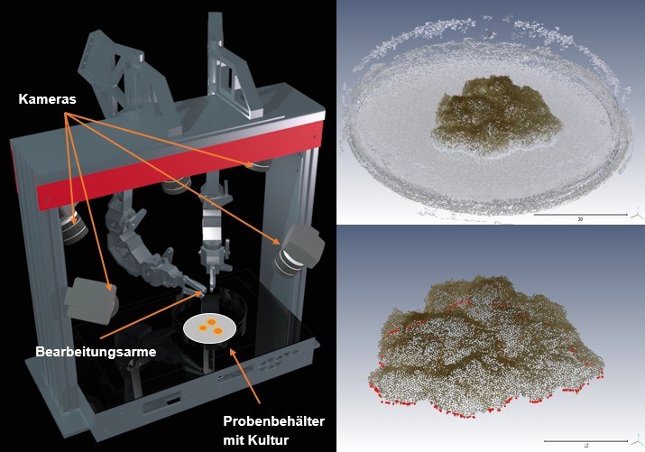
3Dbot - 3D-Erfassung biologischer Proben • Entwicklung und Praxistest einer schnellen Methode für die Erzeugung von 3D – Modellen von biologischen Proben aus multiperspektivischen Bilddaten (gefördert durch FuE-Verbundprojektförderung der SAB - Sächsische Aufbaubank, 2017 - 2020)
Projektleiter Teilprojekt Photogrammetrie

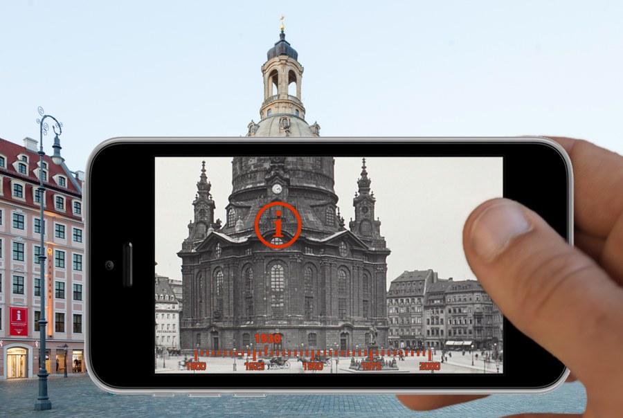
DresdnerStadtGeschichte3D (LiT - Lehrpraxis im Transfer, Hochschuldidaktisches Zentrum Sachsen, Wintersemester 2017/2018)
Projektleiter Teilprojekt Photogrammetrie
Projektleiter Teilprojekt:
HistStadt4D – Multimodale Zugänge zu historischen Bildrepositorien • Automatisierte Geo- und Zeitreferenzierung von historischen Fotoaufnahmen der SLUB-Fotothek und photogrammetrische Erstellung eines historischen 3D-Stadtmodells (BMBF-Nachwuchsfoschergruppe, 2016 - 2020)
Projektleiter Teilprojekt:
Kalibriermethoden und Untersuchung der Genauigkeit terrestrischer Laserscanner • Teil des Projektes Prozessoptimierung, Qualitätsverbesserung & Auswertewerkzeuge für multi-texturierte Oberflächenmodelle (PROQUATO) (BMWi-ZIM-Projekt, Netzwerk GEOkomm e.V., 2017 - 2018)
Projektleiter:
Aufbereitung und Portierung der Lehrmaterialien und Teachlets in OPAL für die Bachelor- und Mastermodule der Professur Photogrammetrie
(abgeschlossen, gefördert durch Multimediafond der TU Dresden)
Projektleiter:
Vision Teachlets – Webbasierte Visualisierung von Algorithmen aus Photogrammetrie und Bildanalyse
(abgeschlossen, gefördert durch Multimediafond der TU Dresden)
Projektbearbeitung:
Integriertes 3-D Panoramamesssystem, Teilprojekt mathematische Modellierung (abgeschlossen, gefördert durch SAB - Sächsische Aufbaubank)
Projektbearbeitung:
Geometrische Modellierung einer Panoramakamera • Geometrische Modellierung, Kalibrierung und photogrammetrische Anwendungen einer hochauflösenden Panoramakamera (abgeschlossen, gefördert durch SAB - Sächsische Aufbaubank)