09.07.2021
Einsatz des mobilen Laserscannings in der Waldforschung

Mobiles Laserscanning
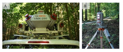
Hintergrund Mobiles Laserscanning (MLS) gewinnt bei der Erhebung wichtiger 3D-Daten in der Waldforschung zunehmend an Bedeutung. Mit mobilen Plattformen ist es möglich, große Waldflächen in kurzer Zeit zu erfassen. Für die weitere Verwendung dieser 3D-Daten in der Forschung ist dann jedoch insbesondere die erfolgreiche Freistellung einzelner Bäume aus den Punktwolken von großer Relevanz. In unserer aktuell im Fachjournal Annals of Botany veröffentlichten Studie präsentieren wir einen neuen Algorithmus, mit dessen Hilfe Einzelbäume in MLS-Punktwolken automatisch freigestellt werden. Dabei wird eine Distanzanpassung in Abhängigkeit von der Fahrstrecke vorgenommen. Zudem werden eine große Anzahl an Einzelbaumparametern ermittelt.
In dem analysierten Untersuchungsgebiet wurden im Mittel 96% der Bäume, die sich in einem Abstand von bis zu 45m von der Fahrstrecke befanden, automatisch erfasst. Bäume mit einem Abstand von bis zu 30 m von der Fahrstrecke wurden annähernd vollständig freigestellt. Im Vergleich zu Einzelbaumdaten, die aus hochaufgelöstem terrestischem Laserscanning ermittelt wurden, zeigte sich eine hohe Übereinstimmung in der Genauigkeit.
Folgerungen
Außer durch die Eigenschaften der Untersuchungsflächen wird die Detektionsrate von Einzelbäumen in dem MLS-Datensatz stark durch die Entfernung zu dem Fahrweg bestimmt. Der in dieser Studie vorgestellte Algorithmus ermöglicht die Erhebung von wichtigen Baumparametern aus dem MLS-Daten. Somit kann eine flächendeckende automatische Ermittlung wichtiger Daten in sehr kurzer Zeit erfolgen.
Weitere Einzelheiten in:
Bienert A, Georgi L, Kunz M, von Oheimb G, Maas HG, (in press). Automatic extraction and measurement of individual trees from mobile laser scanning point clouds of forests. Annals of Botany DOI: 10.1093/aob/mcab087
Eine weitere Studie zu den Einsatzmöglichkeiten von MLS in der Waldforschung:
Bienert A, Georgi L, Kunz M, von Oheimb G, Maas HG, (2021). Automatic extraction and measurement of individual trees from mobile laser scanning point clouds of forests. Annals of Botany 128 (6): 787–804. https://doi.org/10.1093/aob/mcab087
