What influences spatial location quality? – Validation of statistical estimates by qualitative research
Dr. rer. nat. Andreas Ortner
Motivation
Analysis and Assessment of Locations - Spatial Distribution and the Influence of Land Value-relevant Aspects
Spatial locations have a great influence on land management activities. They allow the valuation of spatial structures through the assessment and categorisation of representative characteristics as a basis for the formulation of development recommendations and measures. Land value is often used as an indicator of location, although it is known that it represents only a part the spatial location. Based on expert knowledge, data for analyses are usually collected only on selected topics such as economic or social situation.
Approach
Phase I - Operationalisation of spatial locations and analysis of statistical estimates
With the further development of the operationalisation of spatial locations, which includes the integration of additional indicators such as environmental influences or distances and accessibility, more precisely differentiable location assessments can be realised.
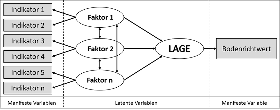
Basic setup of the structural equation model for operationalising spatial locations
By using structural equation models (SEM), the complex relationships of spatial indicators can be explained more clearly. The mathematical explanatory model is less affected by subjective assessments, since the weightings of the spatial indicators are derived from the statistical modelling. Thus, the further development of the operationalisation of spatial locations provides new impulses for an improved location assessment in land management and usability for real estate valuation.
Phase II - Validation of statistical estimates by qualitative research
Qualitative surveys in selected urban neighbourhoods are used to validate the statistical estimates of the mathematical explanatory models for location assessment. The research focusses on the individual perspectives of residents on location-determining parameters and their assessments of their weighting. In addition to analysing the content of the parameters prioritised by the experts, other parameters influencing the location are explored by asking open questions. The focus here is particularly on climate-relevant and mobility-related aspects, which may also have an influence on the assessment of the location.
| Reviewed Publication on the PostDoc-Project |
|---|
| Ortner, A.; Soot, M.; Krause, N.; Weitkamp, A. (2023): Lage? Lage. Lage! – Weiterentwicklung der Operationalisierung räumlicher Lagen im Landmanagement. In: Henn, S.; Zimmermann, T.; Braunschweig, B. (Hrsg.) Stadtregionales Flächenmanagement. Springer Publikation. https://doi.org/10.1007/978-3-662-63295-6_33-1 |
|
Ortner, A.; Jaimes Parra, M. D.; Weitkamp, A. (2020): Using Spatial Indicators to Assess the Quality Level of Residential Locations in Cities – Utility Analysis (UA) versus Structural Equation Modelling (SEM). In: Methods and Concepts of Land Management – Diversity, Changes and New Approaches, 187–198. https://doi.org/DOI:%2010.3218/4027-2 |
|
Ortner, A.; Soot, M.; Weitkamp, A. (2019): Determining Land Values by Location: Supporting Public Valuation Expert Committees in the Provision of Market Transparency. In: Finka, M. et al. (Ed.) The Role of Public Sector in Local Economic and Territorial Development – Innovation in Central, Eastern and South Eastern Europe. 83-96. EAI/Springer Innovations in Communication and Computing. https://doi.org/10.1007/978-3-319-93575-1_6 |
|
Ortner, A.; Weitkamp, A. (2018): "Räumliche Lage" – A Discourse on Location – Concepts for Assessing Interdisciplinary Application Potentials. In: Hepperle, E. et al. (Ed.) Opportunities and Constraints of Land Management in Local and Regional Development – Integrated Knowledge, Factors and Trade-offs. 25-37. vdf Hochschulverlag an der ETH Zürich. https://doi.org/10.3218/3928-3 |
| Weitkamp, A.; Köhler, T.; Ortner, A. (2017): Bodenwertermittlung – Eine automatisierbare Aufgabe? In: fub (Flächenmanagement und Bodenordnung): Nachhaltige Landnutzung. 1/2017 (Februar). 79. Jahrgang, 25-34 |