
Aug 28, 2026
New Study Shows: Wildfire Risks Don't Stop at Borders
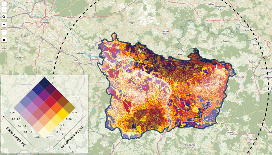
Forest Fire Exposure Map for Saxon-Bohemian Switzerland
Forest fires are becoming a growing challenge in Central Europe as well
The recent wildfires in Central Europe have once again made it clear that wildfire risks are no longer just a problem for the Mediterranean region. Hot and dry summers are increasingly creating conditions under which large and difficult-to-control fires can develop even in Germany, the Czech Republic, and other parts of Central Europe.
A new study conducted at the Chair of Environmental Remote Sensing at TU Dresden examines how severely settlements can be endangered in such situations and how wildfire risks spread across national borders. The paper , “Exposure of settlements to wildfires in a transboundary wildland–urban interface region in Central Europe,” was published by Evripidis Avouris, Christopher Marrs, Kristina Beetz, Lucie Kudláčková, Johanna Kranz, Markéta Poděbradská, Miroslav Trnka, and Matthias Forkel in *Natural Hazards and Earth System Sciences *.
Wildfire Risks in the German-Czech Border Region
The study focuses on the Saxon-Bohemian Switzerland region along the German-Czech border. The area is characterized by valuable forest ecosystems, steep terrain, numerous tourist destinations, and settlements—and was affected in 2022 by a large-scale wildfire in both the Bohemian and Saxon Switzerland National Parks.
The events of 2022 sent a clear signal that the framework conditions for managing forest fires are changing in Central Europe as well. The current forest fires in various parts of Germany and Central Europe confirm the high relevance of this development.
An interactive wildfire exposure map was developed for the study. To create it, various Earth observation data, historical fire events, scenarios for moderate to very high wildfire risk, and different wind conditions were combined. In addition, fire durations of one, two, and three days were simulated to estimate possible fire trajectories and the probability of fires.
Particular attention was paid to identifying which communities are potentially at risk from wildfires. The simulations were validated using observations from the 2022 wildfire. Among other things, the results show different patterns of flame heights and fire probabilities on both sides of the border. While higher flame heights occurred particularly in Czech municipalities, increased fire probabilities were observed in both Germany and the Czech Republic.
Fire knows no administrative boundaries
A key finding of the study is therefore directly relevant to real-world applications: wildfires do not stop at national or administrative borders.
This is precisely where the Interreg project Wildfire CE —co-sponsored by TU Dresden—comes in. In this project, partners from Germany, the Czech Republic, Austria, Italy, and Slovenia are working to better coordinate the assessment, communication, and management of wildfire risks in cross-border regions.
Instead of considering wildfire hazards exclusively on one side of a border, Wildfire CE is developing a shared knowledge base, comparable data, and digital tools for cross-border wildfire prevention. A key component is a shared digital platform that brings together information on fuels, fire behavior, and accessibility, among other things.
From Research to Practice
The new study shows why such cross-border approaches are becoming increasingly important. Dry vegetation, combustible deadwood, steep slopes, and hard-to-reach areas do not adhere to administrative boundaries. For effective prevention and firefighting, these factors must therefore be considered as part of a connected landscape.
In addition to developing digital tools, Wildfire CE supports regional workshops, risk analyses, recommendations for action, and action plans for various cross-border pilot regions. The goal is to bring together experiences from different regions and develop solutions that can be applied to other areas affected by the increasing risk of wildfires.
The current study makes an important scientific contribution in this regard: It demonstrates how Earth observation data, historical fire information, and fire behavior models can be combined to visualize the potential exposure of settlements to wildfires. This creates a knowledge base that can help prioritize prevention measures, identify critical areas, and improve operational planning.
Shared Landscapes Require Shared Strategies
The experiences of recent years—from the major fire in Saxon-Bohemian Switzerland in 2022 to the most recent wildfires in Central Europe—show that the approach to wildfires must change. In addition to better assessment of wildfire risks , there is a particular need for cross-border cooperation, shared data, and coordinated strategies.
With Wildfire CE, TU Dresden is helping to further develop such approaches together with partners in Central Europe. The current publication underscores a central message of the project: If landscapes and wildfires do not stop at borders, neither should wildfire management.
Publication:
Avouris, E., Marrs, C., Beetz, K., Kudláčková, L., Kranz, J., Poděbradská, M., Trnka, M., & Forkel, M. (2026): Exposure of settlements to wildfires in a transboundary wildland–urban interface region in Central Europe. Natural Hazards and Earth System Sciences, 26, 4013–4044.
Link to the publication: DOI: 10.5194/nhess-26-4013-2026
Interactive wildfire exposure map (download): https://opara.zih.tu-dresden.de/bitstreams/f85eed5d-30fe-4d35-bdeb-6ab53e1e9faa/download
Wildfire CE
- Interreg Central Europe, 2024–2027
- https://www.interreg-central.eu/projects/wildfire-ce/
- Budget: €2.25 million
- Partners from Austria, the Czech Republic, Germany, Italy, and Slovenia