Forschungsthemen und -projekte
Inhaltsverzeichnis
Forschungsthemen
Forschungsschwerpunkte der Professur sind die Methodenentwicklung and Anwendung von Satellitendaten und daraus abgeleiteten Produkten zur Beobachtung, Analyse, Modellierung und Prognose von Veränderungen in Land-Ökosystemen und deren Wechselwirkungen mit dem Kohlenstoff- und Wasserkreislauf und dem Klima. Forschungsschwerpunkte sind die Mikrowellenfernerkundung für Wald-Wasser-Interaktionen, die Fernerkundung für Waldbrandforschung und -management sowie Angewandte Fernerkundung für Forst und Landwirtschaft. Dazu nutzen und entwickeln wir daten-basierte Methoden der Zeitreihenanalyse, des maschinellen Lernens, der künstlichen Intelligenz sowie prozess-basierte Strahlungstransfer- und Umweltmodelle und Modell-Daten-Integrationstechniken. Forschungsprojekte und Qualifikationarbeiten decken sowohl Themen der Grundlagenforschung als auch Anforderungen aus der Praxis ab.
Liste aller Publikationen
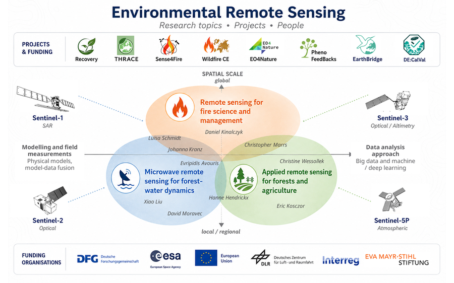
Forschungsthemen der Professur mit räumlichen Skalen und Methoden sowie assoziierte Projekte
Mikrowellenfernerkundung für Wald-Wasser-Interaktionen
Ziel ist die Entwicklung eines Verständnisses der Sensitivität und der physikalischen Beziehungen zwischen Beobachtungen von aktiven und passiven Mikrowellensatelliten und dem Feuchtigkeitsgehalt der Blätter, dem Wassergehalt der Vegetation, der Interzeption und Verdunstung und der Phänologie der Vegetation. Diese Forschung ermöglicht es, die Wassermenge und Biomasse in der terrestrischen Vegetation anhand von Mikrowellen-Satellitenbeobachtungen zu quantifizieren und deren Wechselwirkungen mit den lokalen bis globalen Kohlenstoff- und Wasserkreisläufen zu verstehen und für die Zukunft zu quantifizieren.
Das Thema wird in enger Abstimmung mit dem Potentialbereich „Forest-Water-Dynamics“ der Exzellenzstrategie der TU Dresden entwickelt.
Beteiligte Mitarbeitende
- Evripidis Avouris: Sensitivität von Radar-Satelliten und UAV-Aufnahmen zu Wald-Wasser-Dynamiken
- Johanna Kranz: Ableitung von Phänologie, Live Fuel Moisture Content und Interzeption aus Sentinel-1-Zeitreihen
- Xiao Liu: Abschätzung der vertikalen Struktur und Biomasseverteilung in Wäldern aus Radar- und Lidar-Daten
- David Moravec: Abschätzung des Vegetationswassergehaltes mit Sentinel-1 und Corner Reflektoren
- Luisa Schmidt: Untersuchung globaler Dynamiken im Live Fuel Moisture Content mit langfristigen Zeitreihen des Vegetation Optical Depth
Datensätze und Ergebnisse
- VOD2LFMC: Globaler Blattfeuchtigkeitsgehalt zenodo.org
- Aktuelle Messdaten von unseren Feuerwetterstationen im Landkreis Sächsische Schweiz/Osterzgebirge: emsbrno.cz
Ausgewählte Publikationen
Forkel, M., Schmidt, L., Zotta, R.-M., Dorigo, W., and Yebra, M. (2023).
Estimating leaf moisture content at global scale from passive microwave satellite observations of vegetation optical depth
Hydrology and Earth System Sciences, 27, 39–68, https://doi.org/10.5194/hess-27-39-2023
Liu, X., Neigh, C. S. R., Pardini, M., and Forkel, M. (2024).
Estimating forest height and above-ground biomass in tropical forests using P-band TomoSAR and GEDI observations
International Journal of Remote Sensing, 9, 45, 3129-3148, https://doi.org/10.1080/01431161.2024.2343134
Schmidt, L., Forkel, M., Zotta, R.-M., Scherrer, S., Dorigo, W. A., Kuhn-Régnier, A., van der Schalie, R., and Yebra, M. (2023).
Assessing the sensitivity of multi-frequency passive microwave vegetation optical depth to vegetation properties
Biogeosciences 20, 1027–1046, https://doi.org/10.5194/bg-20-1027-2023
Fernerkundung für Waldbrandforschung und –management
Ziel ist es, verschiedene Beobachtungen aus der optischen und Mikrowellen-Fernerkundung zu kombinieren und integrative Methoden zu entwickeln, um verschiedene Aspekte von Waldbränden wie die Brandlast, Brennmaterialfeuchte, die Brandgefahr, die Entwicklung von Bränden und die Emissionen von Rauch und Treibhausgasen zu quantifizieren und zu überwachen.
Im Rahmen dieser Forschungslinie arbeiten wir einerseits eng mit internationalen Forschungsgruppen zum globalen Kohlenstoffkreislauf und der Europäischen Weltraumagentur sowie anderseits mit Praktikern aus Feuerwehr- und Forstbehörden und der öffentlichen Verwaltung zusammen.
In der Professur wurde u.a. der weltweit einmalige und führende TUD-S4F-Ansatz entwickelt, welcher global eine räumlich hochaufgelöste Quantifizierung von Brandlasten, Feuerverhalten und Waldbrandemissionen ermöglicht (Forkel et al. 2025).
Beteiligte Mitarbeitende
-
Matthias Forkel: Großräumige Überwachung und Modellierung von Brennstoffen, Bränden und Brandemissionen; Rolle des Feuers im Kohlenstoffkreislauf; Modell-Daten-Integration für Dynamische Globale Vegetations-Feuer-Modelle
-
Daniel Kinalczyk: Bewertung der Auswirkungen von Strauchbewuchs auf Brennstoffmengen und Brandemissionen; Entwicklung des S4F-Ansatzes zur Daten-Modell-Fusion
-
Johanna Kranz: Dynamik der Brennstofffeuchte und des Feuerwetters in Mitteleuropa
-
Xiao Liu: Kartierung von Sträuchern und Unterholz als Brennstoff für die Abschätzung von Brandemissionen
-
Christopher Marrs: Grenzüberschreitende Bewertung, Kommunikation und Management von Waldbrandrisiken in Mitteleuropa
-
Luisa Schmidt: Globale Dynamik des Feuchtigkeitsgehalts von lebendem Brennstoff; Modellierung von Torfböden zur Abschätzung von Brandemissionen
Datensätze und Ergebnisse
- Sense4Fire: Experimentelle Datenbank für Brennstoffe und Feueremissionen sense4fire.eu/database
- Feuer in der Böhmisch-Sächsischen Schweiz 2022: Brennstoffarten, Brandschwere, Feuerstrahlungsleistung zenodo.org
Ausgewählte Publikationen
Beetz, K., Marrs, C., Busse, A., Poděbradská, M., Kinalczyk, D., Kranz, J., and Forkel, M. (2024).
Effects of bark beetle disturbance and fuel types on fire radiative power and burn severity in the Bohemian-Saxon Switzerland
Forestry: An International Journal of Forest Research, cpae024, https://doi.org/10.1093/forestry/cpae024
Forkel, M., Wessollek, C., Huijnen, V., Andela, N., de Laat, A., Kinalczyk, D., Marrs, C., van Wees, D., Bastos, A., Ciais, P., Fawcett, D., Kaiser, J.W., Klauberg, C., Kutchartt, E., Leite, R., Li, W., Silva, C., Sitch, S., Goncalves De Souza, J., Zaehle, S., Plummer, S. (2025).
Burning of woody debris dominates fire emissions in the Amazon and Cerrado.
Nature Geoscience, 18, 140-147. https://doi.org/10.1038/s41561-024-01637-5
Kranz, J., Bauer, K., Pampanoni, V., Zhao, L., Marrs, C., Mauder, M., Poděbradská, M., van der Maaten-Theunissen, M., Yebra, M., and Forkel, M. (2025).
Assessing predictors for fuel moisture content in Central European forests.
Agricultural and Forest Meteorology, 371, 110590, https://doi.org/10.1016/j.agrformet.2025.110590
Angewandte Fernerkundung für Forst und Landwirtschaft
Ziel ist die Anwendung von Fernerkundungsdaten für das Monitoring von historischen bis kurzfristigen Veränderungen in forstlichen und Agrarlandschaften und um Entscheidungen in der Land- und Forstwirtschaft, im Naturschutz und der Landschaftsplanung zu unterstützen. Dabei kommen v.a. Methoden der Bildanalyse und künstlichen Intelligenz zum Einsatz. Beispielsweise wurden historische Spionagebildern aus den 1960er Jahren mit Deep Learning-Methoden ausgewertet um für ganz Sachsen Veränderungen in Landschaften zu kartieren. Projekte mit dem Sächsischen Landesamt für Umwelt, Landwirtschaft und Geologie fokussieren darauf Methoden für das Monitoring des guten landwirtschaftlichen und ökologischen Zustandes von Agrarlandschaften zu entwickeln.
Beteiligte Mitarbeitende
- Hanne Hendrickx: Monitoring von Wasserstress und Vitalität in Buchenwäldern mit thermalen und multispekralen UAV- und Satellitendaten
- Eric Kosczor: Kartierung langfristiger struktureller Veränderungen in Agrarlandschaften; Erkennung von Anomalien im ökologischen Zustand von Agrarlandschaften
- Christopher Marrs: Transfer von Fernerkundungsansätzen für die Überwachung der biologischen Vielfalt, die Erkennung von Veränderungen und die Landschaftsplanung an Interessengruppen
- Christine Wessollek: Anwendung der Fernerkundung in der Agrarüberwachung; Integration der Fernerkundung in ökohydrologische Modelle zur Überwachung der Bodenfeuchte in der Land- und Forstwirtschaft
Datensätze und Ergebnisse
- Historische "Key hole"-Bilde der 1960er ud 1970er Jahre im Geoportal Sachsenatlas
- Phänologie der Landoberfläche von Araukarien-Nothofagus-Wäldern in den Anden zenodo.org
Ausgewählte Publikationen
Kugler, L., Marrs, C., Kosczor, E., and Forkel, M. (2023).
Landbedeckung in Sachsen 1961-1979 (Teil 1). Erfassung von Veränderungen in der Landbedeckung in Sachsen 1961-1979: Analyse anhand historischer CORONA-Spionageaufnahmen und tiefer neuronaler Netze
Schriftenreihe des LfULG, 6/2023, 72, https://publikationen.sachsen.de/bdb/artikel/42436
Kosczor, E., Forkel, M., Hernández, J., Kinalczyk, D., Pirotti, F., and Kutchartt, E. (2022).
Assessing land surface phenology in Araucaria-Nothofagus forests in Chile with Landsat 8/Sentinel-2 time series.
International Journal of Applied Earth Observation and Geoinformation, 112, 102862, https://doi.org/10.1016/j.jag.2022.102862
Forschungsprojekte
Laufende Projekte
DECalVal BIOMASS – Koordinierter deutscher Beitrag zu den BIOMASS Kalibrierungs- und Validierungsaktivitäten
Validating BIOMASS products with forest inventory and UAV lidar data in the Peruvian rainforest
Tropical forests store more above-ground biomass (AGB) than boreal and temperate forests. Remote sensing methods have been used to estimate AGB in tropical forests. However, there is a large uncertainty in the estimation because the signal saturates when the AGB exceeds a certain threshold. ESA BIOMASS mission will be the first P-band SAR satellite. It also has a specifically designed SAR tomography (TomoSAR) phase. The penetration capability of P-band microwave and the unique TomoSAR configuration may provide an unprecedented opportunity to improve the AGB estimation in tropical forests. This project will contribute to the validation of BIOMASS products by making use of forest inventory and unmanned aerial vehicle (UAV) lidar data collected in the Peruvian rainforest. First, the data will be used to validate the BIOMASS forest height, AGB
and forest disturbance products. Second, the sensitivity of P-band TomoSAR reflectivity profiles to the forest vertical structure will be investigated using the lidar point clouds. Besides the validation of BIOMASS products, the project will allow the project partners to
quantify forest biomass and to monitor changes in forest biomass in protected rainforests forests in Peru. This will help to further develop the monitoring activities of the Wilderness International foundation (https://wilderness-international.org/) that is buying pristine rainforests in Peru in order to protect them from exploitation and deforestation.
- Förderung: Deutsches Zentrum für Luft- und Raumfahrt e. V., 10/2025 - 09/2028
- Partner: Wilderness International
- Involvierte Teammitglieder: Xiao Liu, Johanna Kranz, Evripidis Avouris
EO4Nature Bodenfeuchtedienst - Erstellung eines Monitoringdienstes zur Erfassung und Modellierung der Bodenfeuchte
Im Kontext des Aktionsprogramms Natürlicher Klimaschutz (ANK) ist die Implementierung eines Monitoringdienstes vorgesehen, der eine raum-zeitlich hochauflösende und modellgestützte Bestimmung der Bodenfeuchte ermöglicht. Bodenfeuchte stellt eine Schlüsselgröße in terrestrischen Systemen dar, insbesondere im Hinblick auf Kohlenstoffdynamiken, den Landschaftswasserhaushalt sowie die ökologische Resilienz gegenüber klimatischen Extremereignissen. Die Bereitstellung eines flächendeckenden, zeitlich konsistenten und wissenschaftlich fundierten Bodenfeuchtedatensatzes bildet die Grundlage für evidenzbasierte Klimaschutz- und Anpassungsstrategien in natürlichen und naturnahen Räumen.
- Förderung: LUP - Luftbild Umwelt Planung GmbH / Deutsches Zentrum für Luft- und Raumfahrt, 2025 - 2027
- Partner: TUD Professur für Meteorologie, PIKOBYTES GmbH
- Involvierte Teammitglieder: Christine Wessollek, Eric Kosczor
EU Interreg Central Europe: Wildfire CE - Enabling cross-boundary assessment, communication and management of wildfire risks in Central Europe
Climate change increases the threat of wildfires across central Europe. Since they often affect more than one region, fighting these fires needs better cooperation and information sharing. The Wildfire CE project improves the assessment and management of wildfire risks by mapping fire potentials, providing fire assessment manuals, and developing action plans for pilot regions. In cooperation with regional authorities and emergency services, the partners empower local communities and organisations to tackle this transborder challenge with shared knowledge, tools and coordinated actions across borders.
Partners: Saxon State Ministry for Regional Development, European Spatial Planning, Regional Development (Lead partner), TU Dresden, Junior Professorship in Environmental Remote Sensing (Technical lead); University of Padova, Department of Land, Environment, Agriculture and Forestry, Italy; Slovenian Forestry Institute, Ljubljana, Slovenia; University of Natural Resources and Life Sciences, Department of Forest and Soil Sciences, Institute of Silviculture, Vienna, Austria; Czech Environmental Information Agency, Unit of Geoinformatics, Praha, Czechia; Global Change Research Insitute of the Czech Academy of Sciences, Domain of Climate Analysis and Modelling, Brno, Czechia; Municipality of Ajdovščina, Department for Economics and Development, Ajdovščina, Slovenia; Autonomous Province of Trento, Trento, Italy
Funding: Interreg Central Europe. co-funded by the European Union, June 2025 - May 2027
Involved team members: Matthias Forkel, Christopher Marrs, Johanna Kranz, Daniel Kinalczyk, Christine Wessollek
3C – Copernicus Cross Compliance
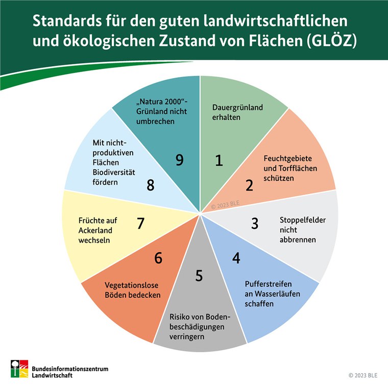
GLÖZ-Standards ab 2023 im Rahmen der Gemeinsamen Agrarpolitik (GAP) der EU
Ziel des Projekts ist die Entwicklung und praktische Implementierung von verschiedenen Ansätzen zum automatischen Monitoring der GLÖZ-Vorgaben mithilfe von Fernerkundungsdaten (vor allem aus den Copernicus-Diensten). Die Juniorprofessur für Umweltfernerkundung ist dabei vorrangig für die Auswahl, Implementierung und Evaluation von geeigneten ML- und Deep-Learning-Methoden zuständig.
- Förderung: Deutsches Zentrum für Luft- und Raumfahrt e. V. im Auftrag des Bundesministerium für Digitales und Verkehr, 07/2023 - 06/2025
- Partner: Sächsisches Landesamt für Umwelt, Landwirtschaft und Geologie
- Involvierte Teammitglieder: Christine Wessollek, Eric Kosczor
EU EarthBridge
Earth Observation (EO) has emerged in recent years as one of themost important methods for regularly obtaining standardised information about the Earth’s changing environment and is therefore critical to addressing climate change, biodiversity decline, and other societal challenges. However, the full utilisation of EO is still limited. The aim of EarthBridge is to increase the knowledge of and ability to apply Earth observation techniques in the Czech Republic for urgent tasks such as biodiversity conservation and landscape adaptation to climate change. Technische Universität Dresden (TUD), Universitá di Bologna (UNIBO), and the Czech University of Life Sciences Prague (CZU) will work toegther to increase use of EO through implementation of a concerted series of networking, knowledge transfer and exchange activities.
Partners: Lead Czech University of Life Sciences Prague, Czechia; Alma Mater Studiorum - Universitá di Bologna, Italy; TU Dresden (Chair of Computational Landscape Ecology, Junior Professorship in Environmental Remote Sensing, Junior Professorship in Geosensor Systems
Funding: European Commission, Twinnings, January 2023 - December 2025
Involved team members: Matthias Forkel, Christopher Marrs, Lucas Kugler, Eric Kosczor
ESA Sense4Fire
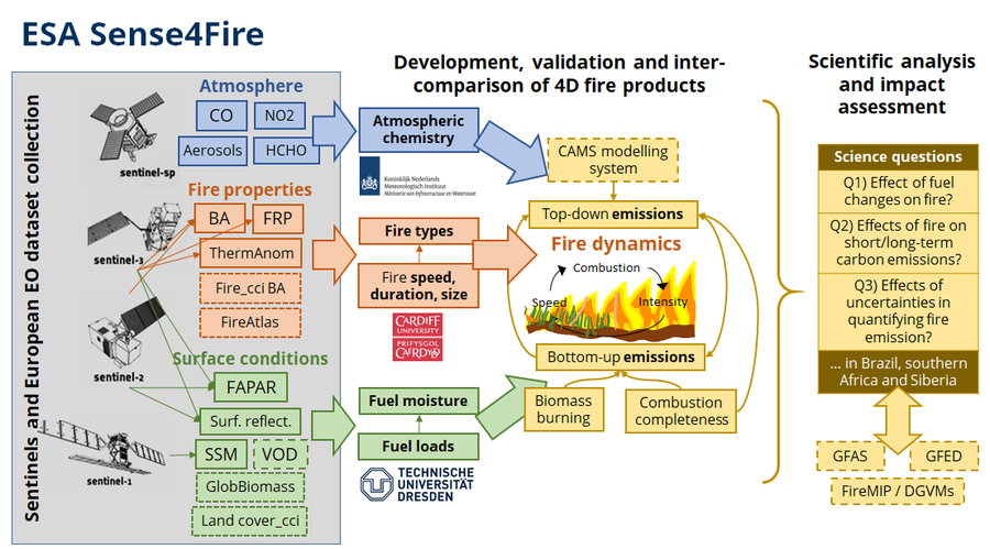
Concept of Sense4Fire
The aim of Sense4Fire is to increase the scientific understanding of fire dynamics and their role in the carbon cycle by integrating observations from the Sentinels into new Earth observation products. We understand fire dynamics as all processes that contribute to pre-fire conditions of the land surface (i.e. fuel loads and fuel moisture), fire behaviour (fire ignitions, spread, speed, size, burned area, thermal emissions and radiative power), combustion and production of fire emissions (combustion completeness, biomass burning, composition of emissions) and the effect of fire emissions on atmospheric composition (injection height, smoke plumes, atmospheric gas composition, aerosols). The aim will be assessed in various test sites and in the three proposed regions of interest, namely Brazil, southern Africa, and Russia/Siberia. The aim will be addressed within the duration of this activity by two specific objectives:
Objective 1: Develop and generate for the three regions of interest novel and advanced geo-information products to quantify the spatial-temporal variability in fuel conditions, fire behaviour and fire emission estimates mainly based on observations from Sentinel-3 and Sentinel-5p and supported by data from Sentinel-1 and -2 and additional European Earth observation datasets.
Objective 2: Demonstrate the value of the novel products in coordination with early adopters to increase the scientific understanding of fires by assessing three science questions related to (1) the effects of fuel dynamics on fire behaviour, (2) the effects of fire behaviour on short- and long-term fire emissions, and (3) the role of uncertainties in estimating fire emissions.
- Partners:
- Royal Netherlands Meteorological Institute (KNMI)
- Cardiff University, School of Earth and Environmental Sciences (in Phase 1)
- BeZero Carbon Ltd. (in Phase 2+3)
- Funding: Europäische Weltraumagentur ESA, Phase 1: August 2021 - Juli 2023; Phase 2: August 2023 - January 2025, Phase 3: Juli 2025 - Dezember 2026
- Project website: https://sense4fire.eu/
- Website at ESA https://eo4society.esa.int/projects/sense4fire/
DFG PhenoFeedBacks
Eine zeitigere Entwicklung der Blätter im Frühling oder eine Veränderung des Eintritts des Blattfalls im Herbst sind Indikatoren für den Einfluss von Klimaänderungen auf die Phänologie der Pflanzen. Die Hauptziele von PhenoFeedBacks sind das Verstehen und Quantifizieren von biophysikalischen Rückkopplungen phänologischer Veränderungen auf das Klimasystem. Auswirkungen auf Veränderungen in der Albedo, im latenten Wärmestrom, Temperatur, Energiebilanz und im Feuchtegehalt der Vegetation werden anhand von Daten weltweiter Beobachtungsnetzwerke und von Satelliten quantifiziert werden. Neue Methoden des maschinellen Lernens werden genutzt um Beziehungen und partielle Sensitivitäten zwischen Veränderungen in biophysikalischen Eigenschaften und Phänologie zu identifizieren.
- Partner: Max-Planck-Institut für Biogeochemie (Mirco Migliavacca).
- Funding: Deutsche Forschungsgemeinschaft, 2021 - 2024
DFG RECOVERY
DFG.
Wir untersuchen die Mechanismen von Veränderungen des Kohlenstoffkreislaufes von nördlichen Landökosystemen. Dazu nutzen wir neue hoch-aufgelöste Satellitenprodukte der Vegetationsbedeckung und deren Veränderung und kombinieren diese mit Biophären- und atmosphärischen Transportmodellen.
- Partner: Universität Augsburg (Wolfgang Buermann), Potsdam-Institut für Klimafolgenforschung (Kirsten Thonicke), Max-Planck-Institut für Biogeochemie (Christian Rödenbeck).
- Förderung: Deutsche Forschungsgemeinschaft, 2021 - 2024
Abgeschlossene Projekte
EU H2020 FirEUrisk
FirEUrisk entwickelt eine wisenschaftlich basierte integrierte Strategie entwickeln, evaluieren und verbreiten um: 1) bisherige Systeme zur Bewertung des Risikos von Vegetationsfeuern auszubauen; 2) effektive Mittel zur Reduzierung von Feuerrisiken zu entwickeln; und 3) Managementstrategien zur Anpassung an zukünftige klimatische und sozioökonomische Veränderungen anzupassen.
Partner: Leitung durch ADAI/Universität Coimbra, Portugal, 38 weitere Partner aus ganz Europa
Finanzierung: H2020, Europäische Kommission, April 2021 - März 2025
Involvierte Teammitglieder: Matthias Forkel, Christopher Marrs, Luisa Schmidt
Die Juniorprofessur für Umweltfernerkundung trägt in FirEUrisk zu verschiedenen Arbeitspaketen und Aktivitäten bei, speziel zu: a) Abschätzung des Feuchtegehaltes von Brennmaterial aus Mikrowellen-Satellitendaten, b) Integration von Satellitendaten und dynamischen globalen Vegetations-Feuermodellen zur Skalierung von Modellprojektionen zukünftiger Feuerrisiken in Europa, c) Leitung des Arbeitspaketes 4 zur Integration von Daten, Modellen und Konzepten, und d) Koordination der Pilotaktivitäten in Mitteleuropa.
NFDI4Earth Educational Pilot
NFDI4Earth
Im Zuge dieses Pilot-Projekts soll Lehrmaterial überarbeitet und entwickelt werden, welches später für die Öffentlichkeit kostenfrei über eine Internetplattform für Open Educational Resources (OER) bereitgestellt werden soll. Inhaltlich werden Themen wie das Vorprozessieren von Satellitendaten, Merkmalsgenerierung und -extraktion und diverse Klassifikations und ML-Algorithmen behandelt. Die als Jupyter-Notebooks in Python erstellten Skripte sollen am Ende auch in der Master-Lehre an der TU Dresden zum Einsatz kommen.
- Förderung: NFDI4Earth, 09/2023 - 12/2023
- Beteiligte Team-Mitglieder: Eric Kosczor, Gianluca Höhnke, Christine Wessollek
LfULG Corona
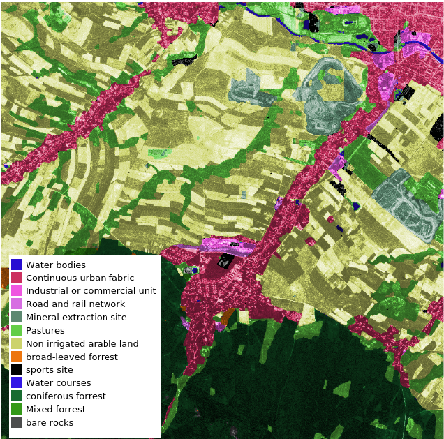
Landbedeckungsklassifikation in einem Gebiet südlich von Zittau auf Grundlage eines CORONA-Bildes vom 3. Mai 1965.
Das Ziel ist die Entwicklung und Umsetzung eines methodischen Ansatzes zur Klassifikation der Landbedeckung in Sachsen ab 1961. Dabei werden historische Satellitendaten des Keyhole-Programms (Corona, Gambit, Hexagon) mit Convolutional Neural Networks (CNNs) ausgewertet.
- Förderung: Sächsisches Landesamt für Umwelt, Landwirtschaft und Geologie, 04/2021 - 11/2022
- Involvierte Teammitglieder: Lucas Kugler, Christopher Marrs
Publikationen
Eine Auflistung aller Publikationen der Juniorprofessur (2019-2025) sowie der Professur für Umweltfernerkundung (ab 2025) ist hier zu finden.