Den globalen Wandel mit Satelliten erforschen
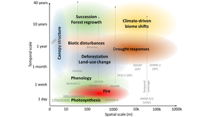
Wir nutzen und entwickeln Satellitendaten und abgeleitete Produkte um Veränderungen der Vegetation und deren Einfluss auf den Kohlenstoff- und Wasserkreislauf in Ökosystemen zu beobachten, analysieren und prognostizieren. Dazu nutzen und entwickeln wir daten-basierte Methoden der Zeitreihenanalyse und des maschinellen Lernens sowie prozess-basierte Umweltmodelle und Modell-Daten-Integrationstechniken.


 © TUD-EnvRS
Research of the Environmental Remote Sensing Group
Wir entwickeln und wenden Satellitendaten und daraus abgeleitete Produkte an, um Veränderungen in der Vegetation, Brände und die damit verbundenen Auswirkungen auf den Kohlenstoff- und Wasserkreislauf in Ökosystemen zu beobachten, zu analysieren, zu modellieren und vorherzusagen. Wir verwenden und entwickeln datengestützte Methoden wie Zeitreihenanalyse und maschinelles Lernen sowie prozessbasierte Umweltmodelle und Techniken zur Modell-Daten-Integration.
Die Forschung der EnvRS-Gruppe gliedert sich in drei miteinander verknüpfte Forschungsthemen. Die Forschungsthemen decken verschiedene Skalen (lokal bis global) ab und nutzen unterschiedliche Ansätze der Datenanalyse in der Fernerkundung (z. B. Feldmessungen, physikalische Modellierung, Strahlungstransfermodellierung, Modellinversion, Zeitreihenanalyse, maschinelles Lernen, Deep Learning):
- Mikrowellen-Fernerkundung von Wald-Wasser-Wechselwirkungen
- Integrative Fernerkundung für Waldbrandforschung und -management
- Fernerkundung für Landschaftsveränderungen und Landwirtschaft