Near-continuous change detection of small river reaches with image-based methods for an improved river management
A major issue for river managers and environmental experts at the local scale is the understanding of the dominant erosion/accretion processes to prevent natural hazards, restrain agricultural damage, and allow for effective floodplain rehabilitation by working with the river without significant alteration of the river processes, especially within the era of climate change extremes in precipitation and runoff. Numerical modeling techniques are a suitable approach for predicting morphodynamic processes. However, a key issue in the validation and applicability of morphodynamic models is the availability of a sufficient amount and reliability of spatial and hydrological data of the studied rivers and sub-reaches. Consequently, near-continuous data collection methods need to be developed to observe and thus better model the local change in hydrological conditions.
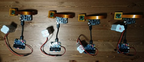
In this project we aim to develop, setup and maintain a stationary system to acquire observation data of selected river reaches and to process the data to measure river bank changes and streamflow (i.e., river stage and discharge measurements). The study area of the project will be sub-reaches of the Hungarian Sajó River, which experience intensive bank erosion, causing significant economic damage.
This project is sponsored by the Federal Ministry of Education and Research and performed in co-operation with the Department of Physical Geography and Geoinformatics, Institute of Earth Sciences, University of Debrecen, Hungary.


