


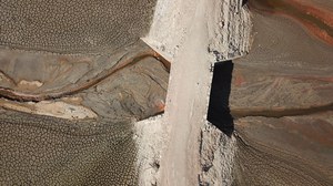

 © Anette Eltner
Welcome to the Junior Professorship in Geosensor Systems
Our environment is dynamic, complex and constantly changing. To understand these changes and develop sustainable solutions, we need innovative technologies: geosensor systems. They are at the heart of our research. Geosensor systems consist of a large number of different sensors that record environmental information on a global, regional and local level. These include
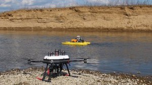
- Ground and terrestrial recording systems: terrestrial and mobile laser scanning as well as photogrammetric multi-camera systems
- Environmental, hydrological and geophysical sensor systems: sensors for the continuous recording of environmental parameters such as water levels and runoff as well as for the detection of ground vibrations, deformations and structural changes in natural and built structures
- Camera and image-based monitoring systems: stationary, mobile and high-resolution camera and time-lapse systems
- UAV and airborne sensor systems: Drones and airborne platforms with high-resolution cameras, laser scanning and multispectral systems
Our research combines state-of-the-art methods for analyzing and interpreting a wide range of sensor data. The focus is on 3D point cloud analysis and photogrammetric reconstruction using structure-from-motion from image sequences. Multi-sensor data fusion is used to integrate camera, LiDAR and environmental data. In addition, deep learning methods enable automated object recognition and classification in large amounts of data. 4D observation extends these approaches to include the temporal dimension and makes dynamic processes such as erosion or glacier movements recordable, detectable and quantifiable.