Development of a comprehensive model for concurrent water surface and bottom reconstruction in photo bathymetry
Project title
Development of a comprehensive model for concurrent water surface and bottom reconstruction in photo bathymetry (PhotoBathyWave)
Contact
- Dr.-Ing. Hannes Sardemann (Project staff)
- Dipl.-Ing. Christian Mulsow (Project staff)
- Prof. Dr. habil. Hans-Gerd Maas (Project manager)
Project partner
- Univ.Prof. Dipl.-Ing. Dr.techn. Gottfried Mandlburger and M.Sc. Laure-Anne Gueguen (TU Wien, Department of Geodesy and Geoinformation, Research Unit of Photogrammetry)
Funding / Duration
German Research Foundation (DFG) / 3 Years (Start: 04/2023)
Description
In the proposed project, the objective is to develop a generic and versatile approach for multimedia photogrammetry through open, dynamic wave-affected water surfaces. For that purpose, our aim is to derive both the shape of the water surface and the submerged bottom topography simultaneously from multi-view images allowing strict geometric modelling of refraction in multi-ray spatial intersection as precondition for precise water bottom coordinate estimation. Application fields are for instance airborne mapping of coastal zones, UAV-based mapping of small rivers or shallow lakes, coral reef change detection, or manifold measurement tasks in hydromechanics laboratory experimental channel facilities.
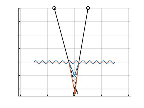
When multimedia photogrammetry is applied, image rays are refracted at the water surface. They are therefore no longer coplanar and the model has to be extended with terms for refraction. When the water surface is non-planar, every image ray is refracted differently. Hence, it is necessary to model the water surface geometry (see the following image). When the water surface is moving, the image coordinate of an object point observation varies over time (see following videos).

Schnittpunkt zweier Bildstrahlen, die an einer sinusförmigen Wasseroberfläche gebrochen werden (blau) im Vergleich zu einer flachen Wasseroberfläche (orange) und ohne Wasser (schwarz)
Underwater object points are refracted through a moving water surface
Movement of the corresponding image points
Relevant Publications
Christian Mulsow, Hannes Sardemann, Laure-Anne Gueguen, Gottfried Mandelburger, and Hans-Gerd Maas (2024): Concepts for compensation of wave effects when measuring through water surfaces in photogrammetric applications. Int. Arch. Photogramm. Remote Sens. Spatial Inf. Sci., XLVIII-2-2024, 289–295, https://doi.org/10.5194/isprs-archives-XLVIII-2-2024-289-2024
Hannes Sardemann, Christian Mulsow, Laure-Anne Gueguen, Gottfried Mandlburger, and Hans-Gerd Maas (2024): Multimedia Photogrammetry with non-planar Water Surfaces – Accuracy Analysis on Simulation Basis. Int. Arch. Photogramm. Remote Sens. Spatial Inf. Sci., XLVIII-2-2024, 363–369, https://doi.org/10.5194/isprs-archives-XLVIII-2-2024-363-2024
