Dec 12, 2021
Surveying the Patagonian glaciers onboard the polar aircraft

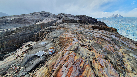
View over Glaciar Grey
FAU geographers explore Patagonia's ice fields together with geodesists from TU Dresden
You are sitting in a small polar plane, flying over the huge ice fields of Patagonia. Travelling to the end of the world is - at least every now and then - part of Matthias Braun's everyday professional life. The professor at the Institute of Geography at Friedrich Alexander University (FAU) Erlangen-Nuremberg observes, measures and researches glaciers, ice shelves, high mountains and polar regions. For his current measurement campaign, he travelled with the research aircraft Polar 5 in southern Patagonia in the first half of November. The work is being carried out in cooperation with Dr Mirko Scheinert from the Institut für Planetare Geodäsie of the Dresden University of Technology (Technischen Universität (TU) Dresden).
The two scientists are working closely with the Alfred Wegener Institute Helmholtz Centre for Polar and Marine Research (AWI), the German Aerospace Center (DLR), the Institute of Geodesy at TU Darmstadt, the Chilean Division General de Aguas Publicas and the Instituto Antártico Chileno as well as the Argentinian Museo Glaciarium. For the current expedition, the Alfred Wegener Institute provided the German research aircraft Polar 5 and made a stopover in Patagonia for several days on the way to Antarctica. The aircraft is specially equipped for conducting flights under the extreme environmental conditions of the polar regions and has a wide range of scientific equipment on board.
Recording the condition of the ice fields
"The aim of the current measurement campaign was to record the condition of the two large ice fields better and more precisely using various methods," explains Braun. Together with Scheinert, he is the scientific PI of the measurement campaign and is primarily interested in the mass changes of the glaciers. He measures these with laser scanning and laser altimetry as well as with high-frequency radar systems. This year, for the first time, the researchers also used high-resolution aerial cameras and brought along photos that are not only used for scientific evaluation, but also show the impressive landscape of the Patagonian ice fields.
On a total of three measurement days, the scientists flew over the central areas of the two Patagonian ice fields and the outlet glaciers. On board the Polar 5 research aircraft, they repeated altitude measurements from other research groups from previous years and collected new data for their research. "Now we are combining the available data sets with our current measurements from satellites and can thus determine the height changes of the glaciers much more precisely," Braun explains.
In addition, the scientists also continuously recorded the meteorological variables during their research flights, as these play an important role in the subsequent modelling. At the same time as the measurement flights, recordings from the German TanDEM-X satellite mission and height measurements in the field were also carried out by German and Chilean research teams. "In the coming weeks and months, correspondingly intensive evaluation work of the collected data material will be carried out to ensure large-scale integration of the measurement profiles," says Braun. The evaluations at FAU and TU Dresden are both being carried out as part of projects funded by the German Research Foundation (DFG). So far, only a few comparable data are available from other regions such as Alaska, Greenland and Antarctica, as comparative measurements for the Earth's ice-covered regions are extremely difficult and costly to obtain.
Spectacular landscape
The scientists want to repeat and expand their measurements with the polar aircraft in the coming years, if possible. Because in addition to the actual measurement data, the researchers also take away unique impressions from the flights. "This is an incredibly spectacular landscape that we get to experience up close during the flights," Braun enthuses. "The impressions from above are simply tremendous. You grasp the dimensions much better and can relate the changes identified in the satellite images even more precisely to the terrain and the processes taking place."
Simultaneous GPS measurements on the ground record deformation of the earth's crust
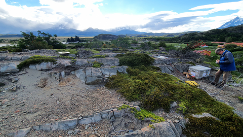
Simultaneously with the aircraft measurements, Lutz Eberlein and Heiner Lange, staff members of the Institut für Planetare Geodäsie at TU Dresden, realised repeated GPS measurements in the southern foreland of the Southern Patagonian Ice Field. "This allows us to derive deformations of the Earth's crust over a period of more than ten years, which are the direct result of changes in the ice mass," says Scheinert. And Eberlein adds, "Realising the measurements presented us with great logistical challenges, as the measuring locations can be reached via gravel road or even only by boat and with not inconsiderable physical effort. However, the magnificent nature of the Torres del Paine National Park compensated for these efforts."
Links
Press release FAU Erlangen-Nuremberg with video link
Press release TU Dresden
Further information
Prof. Dr. Matthias Braun
Friedrich-Alexander-Universität Erlangen-Nürnberg
Institut für Geographie
matthias.h.braun@fau.de
Dr. Mirko Scheinert
Technische Universität Dresden
Institut für Planetare Geodäsie
Mirko.Scheinert@tu-dresden.de


