Jan 02, 2023
In the vastness of Antarctica: GNSS measurements in Dronning Maud Land 2022/2023

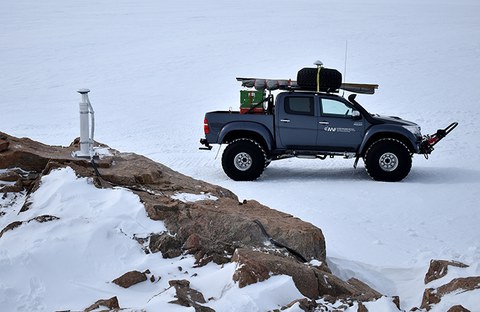
GNSS permanent site KOP1 (Kottas Mountains)
Due to the Corona pandemic, geodetic measurements could not take place in Dronning Maud Land during the past two seasons 2020/2021 and 2021/2022. Therefore, we are all the more pleased that geodetic work in the area of western Dronning-Maud Land will be possible again in the current Antarctic season 2022/2023.
This time we are involved in two expeditions with our working group:
Lutz Eberlein will visit the permanent GNSS stations Forstefjell and Kottas Mts. starting from the German Antarctic station Neumayer III within the framework of ANT-LAND 2022/2023 to perform maintenance work and an extension to include satellite communication (via Iridium). This work will be carried out in close cooperation with the Alfred Wegener Institute (Geophysics Section and Logistics). The transport will be carried out with Toyota Hilux vehicles converted by the company Arctic Trucks, which had already proven themselves during our expedition in 2020.
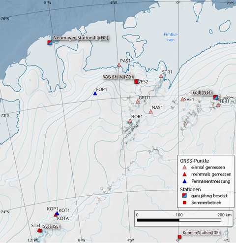
Eric Buchta and Benjamin Schröter are participating in the South African Antarctic Expedition (SANAE). On board the research icebreaker SA Agulhas II they will travel from Cape Town to Antarctica, where they will work based at the SANAE-IV station. The five to six GNSS measurement points will be reached by helicopters which are carried also by the ship. Since the initial measurements were carried out during the JUTEX 2001/2002 measurement campaign realized jointly with AWI Geophysics, we hope to be able to determine the ice-induced deformation of the Earth's crust over a period of more than 20 years by repeating the measurements.

Overview map DML 2022/2023
Project goals
Using GNSS geodetic measurements we aim to determine the deformation of the Earth's crust in Dronning Maud Land, East Antarctica (approximately 71° to 75°S and 13°W to 14°E), at a higher spatial resolution and over a time period of more than 20 years. The response of the solid Earth to present and past ice mass changes, namely the instantaneous elastic response and the glacial isostatic adjustment (GIA), respectively, will be estimated. GIA still causes the largest uncertainty in the satellite gravimetric determination of the Antarctic Ice Sheet mass balance.
The response of the solid Earth is detectable primarily in the vertical coordinate direction as uplift or subsidence of the Earth's crust and amounts to a few millimeters or even centimeters per year. This change in point coordinates can be determined very accurately by means of repeated, precise GNSS measurements. GNSS measurements on bedrock are so far the only way to directly determine the GIA effect.
Comparatively small deformations are expected in the Dronning Maud Land, but so far these have only been determined by a few GNSS measurements. The (linear) vertical deformation rates can be derived with an accuracy of a few mm/yr.
During the field work further GNSS points in the western Dronning Maud Land will be measured repeatedly. In addition, two permanent GNSS stations that were set up in the 2019/2020 season will be checked and maintained.
The project is funded by the German Research Foundation DFG.
Link: https://gepris.dfg.de/gepris/projekt/404719077
Acknowledgment
Our sincere thanks for a fruitful cooperation and the marvellous support go to:
Alfred Wegener Institute Helmholtz Centre for Polar and Marine Research (AWI), Logistics and Section Geophysics
South African National Antarctic Program (SANAP), Department Forestry, Fisheries and the Environment, Republic of South Africa
Further reading
To read a selection of the expedition reports and see further photos, please follow this link.
 © Sven Ellger
Senior Scientist
NameDr.-Ing. Mirko Scheinert
Send encrypted email via the SecureMail portal (for TUD external users only).
