
ERASE - Investigation of the erodibility of deep-sea beds in the context of deep-sea mining in the manganese-nodule licence area, NE Pacific
Table of contents
Funded by the Federal Institute for Geosciences and Natural Resources (BGR).
Project period: January–December 2024.
Project Description
ERASE investigates the erodibility and resuspension of freshly deposited deep-sea sediment in BGR’s German polymetallic-nodule exploration area within the Clarion-Clipperton Fracture Zone, northeastern Pacific. BGR collects geological and environmental reference data there under its agreement with the International Seabed Authority. ERASE combines experiments and numerical simulations to determine how near-bed currents, sediment properties, and seabed topography control remobilisation after mining-induced deposition. The resulting data support estimates of sediment transport, redeposition, and ecological exposure, strengthening environmental-impact assessments for potential manganese-nodule mining
The Science: Resuspend or Remain?
The Problem
Manganese-nodule mining disturbs the seabed and releases fine sediment into turbidity clouds. Deep-sea currents transport these suspended particles away from the mining track before they settle again. Fresh deposits can blanket nodule fields and benthic organisms, but their longer-term fate is uncertain. Depending on sediment properties, near-bed velocity, turbulence, and seabed roughness, the material may remain in place or be resuspended into a secondary plume. Reliable environmental predictions therefore require the critical hydraulic conditions for erosion and the spatial distribution of velocity and bed stress over realistic deep-sea topographies.
Original vs. Sediment-Blanketed Seabeds
Two undisturbed seabed samples containing polymetallic nodules, collected during the SO-262 cruise in 2018, were re-sampled and converted into four three-dimensional seabed topographies. KG-172 and KG-173 were represented in their original nodule-covered state and as sediment-blanketed surfaces representing post-deposition conditions. This paired geometry isolates how a sediment cover smooths the bed relief, buries nodules, and modifies the near-bed flow. The reconstructed surfaces provide a common basis for comparing erosion experiments and CFD simulations under equivalent hydraulic conditions.
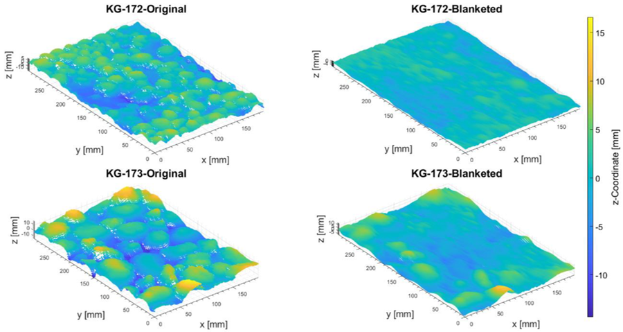
Seabed topographies: original KG-172 and KG-173 nodule fields and their sediment-blanketed reconstructions.
Our Method
ERASE combines controlled erosion experiments with CFD simulations performed on reconstructed deep-sea bed geometries.
Experimental erodibility studies
Freshly deposited deep-sea sediment beds are exposed to controlled hydraulic forcing. The experiments determine when particles begin to move and how resuspension develops as the applied current increases. Comparing original and blanketed configurations quantifies the influence of sediment cover and nodule-scale roughness on erosion
CFD domain and boundary conditions
The three-dimensional scans are incorporated as the lower boundary of a computational flow domain. The numerical mesh represents the measured relief, while prescribed inlet conditions, cyclic lateral boundaries, a slip upper boundary, and no-slip solid surfaces reproduce the experimental hydraulic conditions required to resolve turbulent flow over the seabed
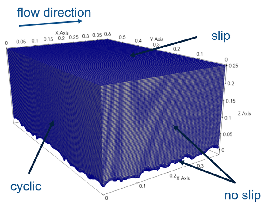
CFD mesh and boundary conditions used to resolve turbulent near-bed flow over the reconstructed seabed.
Velocity-profile prediction
For each imposed inlet velocity, the CFD model predicts the three-dimensional turbulent velocity field and extracts vertical velocity profiles above the irregular seabed. The simulations reveal how nodules, sediment blanketing, and local relief accelerate or shelter the flow. Relating inlet velocity to near-bed velocity and bed shear stress provides the hydraulic basis for predicting where freshly deposited sediment can be resuspended.
Experiment–model integration
The computed velocity and shear distributions are evaluated against the experimental erosion response. Their combination links measured resuspension thresholds to spatially resolved flow conditions and enables transfer from laboratory observations to deep-sea current scenarios.
Project Objectives
- Quantify the erodibility and resuspension of freshly deposited deep-sea sediment under increasing near-bed currents.
- Determine how nodule-scale topography and sediment blanketing modify turbulent velocity profiles and bed shear stress.
- Combine experiments and CFD to predict erosion thresholds and support environmental-impact assessment in the German CCZ licence area.
Project Team & Funding
Principal Investigators
- Prof. Dr.-Ing. Bernhard Vowinckel (TU Dresden)
- Prof. Dr. Jochen Aberle (TU Braunschweig)
Scientific coordination and supervision of the sediment-resuspension experiments, hydraulic analysis, CFD modelling, and environmental application of the project.
Lead Research Associates
- Dr.-Ing. Fabian Kleischmann
- Veronika Saiz M. Sc.
Lead researchers responsible for experimental campaigns, CFD simulations, method implementation, quantitative data analysis, and modelling.
Collaborating Institutions
- Chair of Transport Processes in Hydrosystems, Institute of Urban and Industrial Water Management, TU Dresden
- Department of Hydraulic Engineering and River Morphology, Leichtweiß-Institute for Hydraulic Engineering and Water Resources, TU Braunschweig
Funding Body
Federal Institute for Geosciences and Natural Resources (BGR)
Project information and figures supplied by the ERASE project team.