Smartphone-based behavior data in bicycle traffic - Validation of usability and development of an analysis guideline for bicycle traffic planning
With the 2020 National Cycling Plan the German Federal Government is actively promoting bicycle traffic. In doing so, it is exercising its responsibility as a moderator, coordinator and initiator of bicycle promotion. With this proceeding a sustainable mobility as well as the creation of attractive cities and municipalities is supported. The National Cycling Plan is conducive to initiate a broad societal dialog about new ways to promote cycling as well as implementation strategies to do so. It is also meant to provide guidelines and generally contribute to a bicycle-friendly climate in Germany.
The Chair of Transport Ecology as well as the Chair of Traffic and Transportation Psychology are currently supporting this proceeding with the project
“Smartphone-based behavior data in bicycle traffic - Validation of usability and development of an analysis guideline for bicycle traffic planning”
under Prof. Dr. Udo Becker’s and Prof. Dr. Bernhard Schlag’s leadership. The project is funded by the Federal Ministry of Transport and Digital Infrastructure (BMVI).
Motivation and Project Description
For an attractive bicycle traffic, a qualitative valuable infrastructure is needed. Hence, the extension and maintenance of cycling infrastructure within the corresponding responsibilities are main goals of the National Cycling Plan as well as local authorities. This is where the project comes into existence: It aims at providing local authorities with a tool to comprehensively capture the transport demand as well as quality of the bicycle traffic flow, based on existing big data. Such a comprising data basis is needed to change the paradigm from a supply- to a demand-oriented planning process.
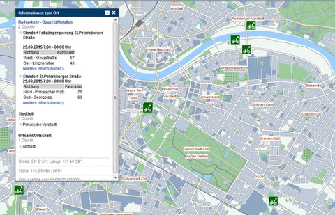
Right now only punctual traffic intensity data exists - temporally as well as locally. This is due to the enormous effort of on-site data gathering and causes a lack in the understanding of the bicycle subnet. The following map shows all the traffic counting systems in the pilot city Dresden. It exposes that these systems cannot provide comprehensive bicycle traffic data for Dresden.
An opportunity to optimize and expand the gathering of cycling-related information is the use of GPS data. Smartphones – attached to bicycle handlebars or taken along in clothing – are catching all of the user’s motion data automatically via satellite positioning (GPS). The operators of smartphone-based cycling apps have been recording their users’ routes for years already. Since 2014 at least one vendor (Strava, Inc) is offering to sell aggregated and anonymous data sets to interested stakeholders in the field of cycling planning (e. g. local authorities, planning agencies, associations). The GPS-based data is enabling to create comprehensive maps of traffic volume and matrices of origins and destinations as well as to calculate area-related average speeds and standing times at intersections. Single routes in corridors can also be reproduced.
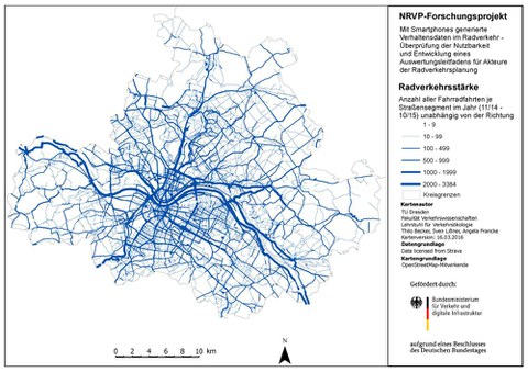
Hence, GPS data helps detecting the Level of Service for bicycle traffic in general. In addition, it can be aimed for a perspective comparison of transport demand and offer, which would usefully support the planning process in local communities. The following picture shows a GPS mapping of Dresden’s bicycle traffic. The main routes can be recognized by the lines’ thickness.
Nevertheless methodical knowledge for data analysis is currently still missing and the suitability of these data for planning processes is not yet proven. This is especially the case regarding the different potential purposes as well as the possibly missing representative status of these data sets. Due to the above mentioned deficits the project’s goal is the following: The usability of existing cycling-related GPS mass data for the planning of bicycle infrastructure in Germany is to be proven. Within the execution of a feasibility study the existing data is tested and the adaptability of an extrapolation methodology for local authorities in Germany is being verified.
In summing up the objectives are the following:
- Use of GPS mass data in the planning of cycling infrastructure
- Test of plausibility and representative status
- Developing suitable forms of visualisation
- Developing an extrapolation or correction methodology
- Creation of a guideline containing recommendations and work steps for local authorities
Project Output
Within the project, we published a manual for municipalities planning to work with GPS-based data. You can download the manual here.
The scientific report can be found here (in German only) .


