Dec 15, 2022
HarvesterNavi - Navigation assistance system for a harvester using reliable and high-precision wireless sensor network positioning for more sustainable forestry.
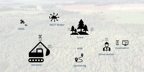
With the help of current IoT technologies, new fields of application are being developed in the area of forestry. To this end, an assistance system for increasing the efficiency of forestry machines and a safety system for forestry workers are being created in the project.
For this purpose, wireless sensor networks (WSN) are used in the forestry environment for the following use cases:
- Assistance system with optimized route planning
- Safety system to warn operators in forestry vehicles when a forestry worker enters the danger zone (analogous to the blind spot assistant in the automotive sector)
A major challenge here is the limited functionality of the global navigation satellite system (GNSS) for determining the location in the sometimes densely overgrown forest.
Supported by industry partners Metirionic and Trans4mation IT GmbH the ITVS evaluates the geometric relations between the individual wireless nodes using algorithms developed in-house. Distance and angle information is used as the basis for locating people (forest workers) and objects (trees, harvesters). These input variables are used to develop and implement robust and adaptive positioning algorithms. Especially due to the radio complex propagation conditions (shadowing / reflections) distance and angle measurement errors occur, which can be corrected with advanced signal processing.
Due to the special requirements and the resulting modular system architecture, HarvesterNavi offers a universal, infrastructure-free localization and warning system, which could conceivably be used for a variety of other applications in addition to forestry.
Stay tuned for more updates….

