Forschungsdatensätze
Inhaltsverzeichnis
As part of our research, we produce datasets that we make available to the public for further applications and research. Usually we publish datasets once they are mature, well tested and validated. Those datasets are published along with scientific publications. In rare cases we also publish experimental datasets that are still in development and for which an comprehensive evaluation is still ongoing but which are of high interest for the scientific community.
Sense4Fire: Experimental database of fuels and fire emissions

S4F Fuel and Fire Emissions Data-Model Fusion
Description: The Sense4Fire Experimental database contains fuel loads, fuel consumption and fire emissions for the Amazon/Cerrado, souther Africa and eastern Siberia derived from the S4F data-model fusion approach by using the Copernicus Proba-V/Sentinel-3 LAI and fCOVER, and ASCAT soil water index, ESA CCI land cover (v2.1.1), ESA CCI above-ground woody biomass (v3.0), and ESA CCI fire burned area maps (v5.1) as input.
- Spatial coverage and resolution: Amazon/Cerrado, eastern Siberia and southern Africa; 333m x 333m
- Temporal coverage and resolution: January 2014 – October 2021, 10-daily
- Version and download: Versiond v01 and v02 at sense4fire.eu/database (contact Christine Wessollek to get access)
- Related publication: ATBD v2.1, PVR 2.1 also available at sense4fire.eu/database
VOD2LFMC: Global leaf moisture content
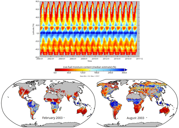
Impression of the VOD2LFMC dataset.
Description: The VOD2LFMC dataset contains global estimates of leaf moisture content as defined as live-fuel moisture content (LFMC) derived from passive microwave satellite observation of vegetation optical depth (VOD). LFMC is defined as the fresh mass of a leaf over the dry mass.
- Spatial coverage and resolution: Global; 0.25 x 0.25°
- Temporal coverage and resolution: February 2000 – July 2017, daily
- Version and download: Version v01 at zenodo.org
- Related publication: Forkel, M., Schmidt, L., Zotta, R.-M., Dorigo, W., and Yebra, M. (2023). Estimating leaf moisture content at global scale from passive microwave satellite observations of vegetation optical depth. Hydrology and Earth System Sciences, 27, 39–68, https://doi.org/10.5194/hess-27-39-2023
Land Surface Phenology of Andean Araucaria-Nothofagus forests
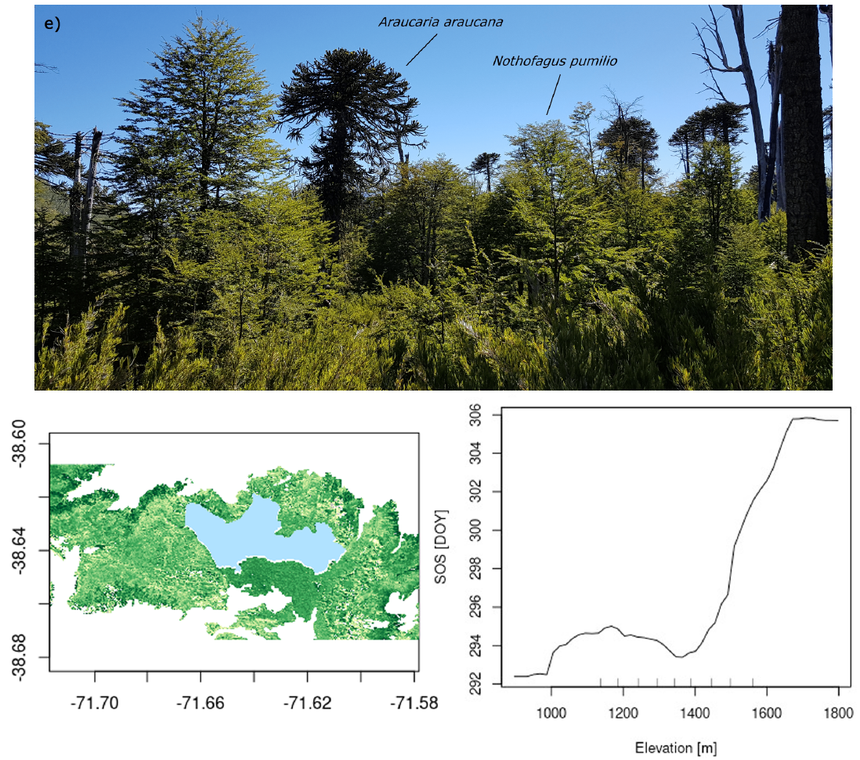
Land surface phenology derived from Sentinel-2 and Landsat in the Conguillío National park, Chile.
Description: This dataset contains the Enhanced Vegetation Index (EVI) and land surface phenology metrics (start of season, end of season) derived from Sentinel-2 and Landsat 8 data for Andean Araucaria-Nothofagus forests.
- Spatial coverage and resolution: Conguillío National Park, Chile; 10 x 10 m
- Temporal coverage and resolution: 2016-2020, annual phenology metrics
- Download at zenodo.org
- Related publication: Kosczor, E., Forkel, M., Hernández, J., Kinalczyk, D., Pirotti, F., and Kutchartt, E. (2022). Assessing land surface phenology in Araucaria-Nothofagus forests in Chile with Landsat 8/Sentinel-2 time series. International Journal of Applied Earth Observation and Geoinformation, 112, 102862, https://doi.org/10.1016/j.jag.2022.102862