Glacier4D: Glacier margin change monitoring on the basis of multi-temporal 3D point clouds
Project title
Glacier4D: Glacier margin change monitoring on the basis of multi-temporal 3D point clouds
Funding / Duration
German Research Foundation (DFG) / 3 years (Start: 01/2021)
Project number: 436500674 (-> GEPRIS)
Description
In response to global climate change, glaciers worldwide indicate significant and partly massive changes, primarily characterised by glacier front retreat and thinning. Both of these correspond to a loss of ice mass. Glacier monitoring typically focuses on measuring the retreat and advance as an indicator of climatic change, which can be obtained from monoscopic satellite, aerial or terrestrial imagery. While the frontal position of glaciers calving into seas and lakes can usually be well identified in images, the frontal position of debris-covered or rock glaciers is often difficult to detect and is one of the main error sources in glacier mapping.
The project aims to develop photogrammetric methods for the reliable mapping of debris-covered glacier fronts. The main focus is on high mountain glaciers, as they interact very sensitively with climate change and show excessive retreat in some areas. Known methods employ image segmentation and classification techniques using different spectral bands, which are not very effective for debris-covered glaciers.
A solution can be found in the spatio-temporal extension of the 2D image space and thus in a 4D approach: While it is often almost impossible to delineate the margin of a debris-covered glacier in 2D images, height changes induced by glacier retreat (or advance) can be reliably detected in multi-temporal 3D surface models generated from stereoscopic image pairs, and thus the relative margin position. In order to identify stagnant glacier outlines, the approach is extended by tracking unique features at the surface to detect margins by segmenting static and dynamic parts of the glacier.
The methods will be developed with respect to different scales ranging from mid-resolution satellite imagery to high-resolution satellite imagery, aerial imagery and UAV (unmanned aerial vehicle) imagery. Three study areas with different spatial extents and characteristics are currently planned for validation, although the applicability of the methods is not limited to these:
- Boverbrean, Jotunheimen National Park (Norway)
- Bellinghausen Dome, King George Island (Antarctica)
- Aletsch Glacier, Alps (Switzerland)
- Skeiðarárjökull, Vatnajökull (Iceland)
Virtual flyover using a 3D surface model of Bellinghausen Dome, King George Island (Antarctica) from UAV images (03/2019) © IPF

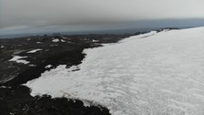
Debris-covered margin of Bellingshausen Dome (oblique UAV image (DJI Mavic Air), 03/2019) © IPF

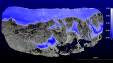
Change detection at Bellinghausen Dome, King George Island, using two 3D surface models from UAV images (Temporal offset: 03/2019 | 02/2020). Mapping of significant decreases of debris-covered glacier and snow areas in metres. © IPF

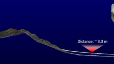
Change detection at Bellinghausen Dome, King George Island, using two 3D surface models from UAV images (Temporal offset: 03/2019 | 02/2020). Co-registration of the 3D point clouds and change detection in a profile section (unit: metres). © IPF
Related papers
Subject to change without notice!
2025
-
Photogrammetric techniques in hydrographic environmental monitoring, 3 Dec 2025, In: International hydrographic review / spons. by the International Hydrographic Bureau, IHB. 31, 2, p. 12-29, 18 p.Electronic (full-text) versionResearch output: Contribution to journal > Review article
-
AI-based tracking of fast-moving alpine landforms using high-frequency monoscopic time-lapse imagery, 8 Aug 2025, In: Earth surface dynamics. 13, 4, p. 705–721, 17 p.Electronic (full-text) versionResearch output: Contribution to journal > Research article
-
Advancing plant biomass measurements: Integrating smartphone‐based 3D scanning techniques for enhanced ecosystem monitoring, 18 Jun 2025, In: Methods in Ecology and Evolution. 16, 8, p. 1723-1732, 10 p.Electronic (full-text) versionResearch output: Contribution to journal > Research article
-
Planet4Stereo: A Photogrammetric Open-Source Pipeline for Generating Digital Elevation Models for Glacier Change Monitoring Using Low-Cost PlanetScope Satellite Data, 2 Apr 2025, In: Remote sensing. 17, 8, 27 p., 1435Electronic (full-text) versionResearch output: Contribution to journal > Research article
-
Automated change detection in photogrammetric 4D point clouds – transferability and extension of 4D objects-by-change for monitoring riverbank dynamics using low-cost cameras, 22 Mar 2025, In: Applied Geomatics. 17 (2025), 2, p. 367-378, 12 p.Electronic (full-text) versionResearch output: Contribution to journal > Research article
-
AI-Driven Approaches applied on Time-Lapse Imagery to Monitor Landform Kinematics, 18 Mar 2025Electronic (full-text) versionResearch output: Contribution to conferences > Abstract
-
Unlocking the potential of historical aerial and spy satellite stereo-imagery in geosciences: access, processing, and applications, 18 Mar 2025Electronic (full-text) versionResearch output: Contribution to conferences > Abstract
-
Subpixel Automatic Detection of GCP Coordinates in Time-Lapse Images Using a Deep Learning Keypoint Network, 2025, In: IEEE Transactions on Geoscience and Remote Sensing. 63, 14 p., 5601714Electronic (full-text) versionResearch output: Contribution to journal > Research article
2024
-
Development and Evaluation of a Two-Staged 3D Keypoint Based Workflow for the Co-Registration of Unstructured Multi-Temporal and Multi-Modal 3D Point Clouds, 10 Jun 2024, In: ISPRS Annals of the Photogrammetry, Remote Sensing and Spatial Information Sciences. X (2024), 2, p. 113–120, 8 p.Electronic (full-text) versionResearch output: Contribution to journal > Research article
-
UAS Photogrammetry for Precise Digital Elevation Models of Complex Topography: A Strategy Guide, 10 Jun 2024, In: ISPRS Annals of the Photogrammetry, Remote Sensing and Spatial Information Sciences. 10, 2, p. 57–64, 8 p.Electronic (full-text) versionResearch output: Contribution to journal > Conference article
Contact
- Dr.-Ing. Melanie Elias (Processing)
- M. Sc. Steffen Isfort (Processing)
- Prof. Dr. habil. Hans-Gerd Maas (Project leadership)


