Laser bathymetry in nearshore areas of the North Sea
Project title
Laser bathymetry in nearshore areas of the North Sea
Funding
Federal Maritime and Hydrographic Agency (BSH)
Website of the BSH about the project
Description
Airborne laser bathymetry is an airborne laser scanning method for determining the water bottom topography in waters with shallow to medium water depths and a low degree of turbidity. The topic is currently attracting great interest, since on the one hand new sensor developments enable the recording of the topography of water bodies with a significantly higher level of detail, and on the other hand EU directives stipulate the regular hydrographic recording of water bodies. Given the depth of penetration of green laser light into water (up to about 50 meters in very clear water), laser bathymetry is particularly suitable for areas where conventional recording using echosounding methods is inefficient due to the narrow swath widths resulting from the aperture angles of such systems. The altitude of an aircraft above the water surface gives laser bathymetry significant advantages in these areas.
Limitations of the real applicability or the achievable accuracy of laser bathymetry result primarily from two factors:
-
Water surface: In contrast to conventional airborne laser scanning, the laser beam path in laser bathymetry is characterized by effects of refraction at the water surface and effects of dispersion in the water. Both cause systematic geometric shifts of ground points as well as degradation of the signal. The use of current high-resolution bathymetry laser scanner systems requires new concepts of geometric modeling, where in particular wave effects are no longer negligible when modeling the refraction-induced laser beam trajectory change. Waves at the water surface represent a spatiotemporally variable interface in beam refraction according to Snellius' law of refraction. Neglecting the effects of waves leads to systematic and random errors in the bottom topography, the magnitude of which exceeds the principal accuracy potential of laser bathymetry. The spatio-temporal modeling of the water surface, e.g. by parameterized water surface models requires a considerable additional effort, but allows the calculation of the refraction for each individual laser pulse and thus provides a basis for a significant increase of the accuracy potential.
-
Water turbidity: The laser beam propagation after refraction at the water surface is characterized by absorption and scattering under water, which significantly attenuates the water bottom echo, making it difficult to detect points on the water bottom. While the digitized pulse echo (FWF - full waveform) should ideally have two clear maxima for the echoes from the water surface and from the water bottom, the water bottom echo will be significantly weaker in medium or high water turbidity and will not always be reliably detectable with standard methods. Here, the application of non-linear waveform stacking techniques lends itself - under assumptions about the continuity of the water bottom - to detect weak bottom echoes more reliably and thus significantly improve the depth range of laser bathymetry.
The work in the research project aims at improving the application potential of laser laser bathymetry and the necessary validation of the accuracy and reliability of laser bathymetry data.

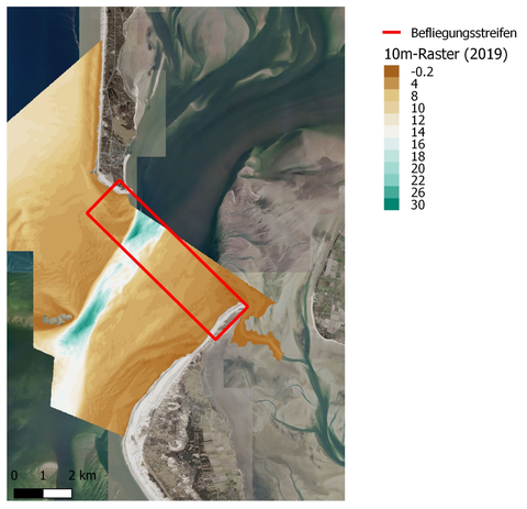
Water bottom topography south of the island of Sylt (Germany) in 2019
Relevant publications
- Mader, D., Westfeld, P., Richter, K. & Maas, H.-G. (2022). Laserbathymetrie in küstennahenBereichen der Nordsee: Entwicklung erweiterter Auswerteverfahren und deren Qualitätssicherung. DVW e.V. (Hrsg.):Hydrographie - Messen mit allen Sinnen, 102, 117-126. DVW-Schriftenreihe.
- Mader, D., Richter, K., Westfeld, P. & Maas, H.-G. (2023). Volumetric nonlinear ortho full-waveform stacking in airborne LIDAR bathymetry for reliable water bottom point detection in shallow waters. ISPRS Journal of Photogrammetry and Remote Sensing, 204, 145–162. https://doi.org/10.1016/j.isprsjprs.2023.08.014
-
Mader, D., Richter, K., Westfeld, P., Nistad, J.-G. & Maas, H.-G. (2023). Analysis of the potential of full-waveform stacking techniques applied to coastal airborne LIDAR bathymetry data of the German Wadden Sea National Park. International Hydrographic Review, 29(2), 46–64. https://doi.org/10.58440/ihr-29-2-a31
-
Mader, D. (2023). Entwicklung von Full-Waveform Stackingverfahren zur Detektion schwacher Gewässerbodenechos in der Laserbathymetrie [Dissertation]. Technische Universität Dresden. Electronic (full text) version
Contact
- Dr.-Ing. Katja Richter (Processing)
- Dr.-Ing. David Mader (Processing)
- Prof. Dr. habil. Hans-Gerd Maas (Project Manager)
- Dr.-Ing. Patrick Westfeld (Contact BSH)
