07.05.2025
Bewegungen der Erdkruste in Antarktika: Datensatz aus umfassender Auswertung geodätischer GNSS-Messungen veröffentlicht
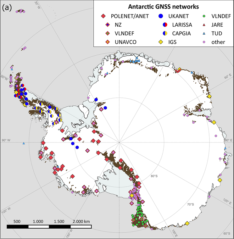
Verteilung der GNSS-Stationen in Antarktika
Im Fachblatt Earth System Science Data wurde am 6. Mai 2025 ein neuer, umfassender Datensatz zu Bewegungen der Erdoberfläche in der Antarktis vorgestellt. Unter der maßgeblichen Mitwirkung von Wissenschaftlern der Professur für Geodätische Erdsystemforschung wurden dafür Messdaten von geodätischen GNSS-Stationen in der Antarktis ausgewertet. Diese Stationen zeichnen die Signale von Global Navigation Satellite Systems (GNSS) mit Hilfe von speziellen Antennen und Empfängern auf, die dann im Postprocessing analysiert werden.
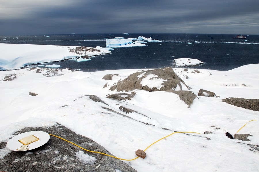
GNSS-Kampagnenstation Pine Island Bay, Westantarktika.
Für die veröffentlichte Studie wurden erstmalig Messungen weitestgehend aller verfügbaren, antarktisweit verteilten Stationen über einen Zeitraum von 1995 bis 2021 erschlossen und genutzt. Dafür initiierte der TU-Wissenschaftler Mirko Scheinert gemeinsam mit Matt King von der University of Tasmania in Hobart (Australien) die Geodynamics In ANTarctica based on REprocessing GNSS dAta INitiative (GIANT-REGAIN), unterstützt durch das Scientific Committee on Antarctic Research (SCAR) und deren Expertengruppe Geodätische Infrastruktur in Antarktia (EG GIANT). Der Erfolg des Projekts war nur aufgrund dieser hervorragenden internationalen Zusammenarbeit im Rahmen von SCAR möglich, wodurch die Messdaten von den vielen verschiedenen nationalen Antarktisprogrammen zur Verfügung gestellt wurden.
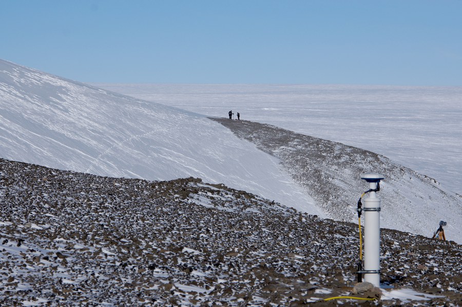
GNSS-Permanentstation Gaussberg, Ostantarktika.
Vier Analysezentren – TU Dresden, University of Tasmania (Australien), Ohio State University (USA) und Newcastle University (Großbritannien) – haben die Daten zuerst unabhängig voneinander mit verschiedener Software, aber nach einheitlichen Regeln ausgewertet, bevor eine gemeinsame, kombinierte Lösung abgeleitet wurde. Als wichtigstes Produkt der Studie stehen für 286 Stationen Zeitreihen von Punktkoordinaten mit den Nord-, Ost- und Vertikalkomponenten zur Verfügung, die bei PANGAEA, dem deutschen Repositorium für georeferenzierte Daten der Erdsystemforschung, frei heruntergeladen werden können.
Diese Koordinatenzeitreihen bilden eine unschätzbare Grundlage für die weitere Erforschung der Geodynamik Antarktikas. Insbesondere bewegt sich die Erdoberfläche in Reaktion auf veränderte Eisauflasten. Die Trennung zwischen den Effekten gegenwärtiger und vergangener Eismassenänderungen stellt dabei eine hochaktuelle Forschungsfrage dar. Es wird international geforscht und diskutiert, wie der glazial-isostatische Ausgleich als Reaktion der festen Erde auf Eismassenänderungen, die bis zum letzten glazialen Maximum zurückreichen, besser beschrieben werden kann. Erkenntnisse aus diesen Forschungen bilden ein zentrales Bindeglied bei der Beurteilung vergangener, gegenwärtiger und zukünftiger Änderungen der kontinentalen Eismassen und des Meeresspiegels.
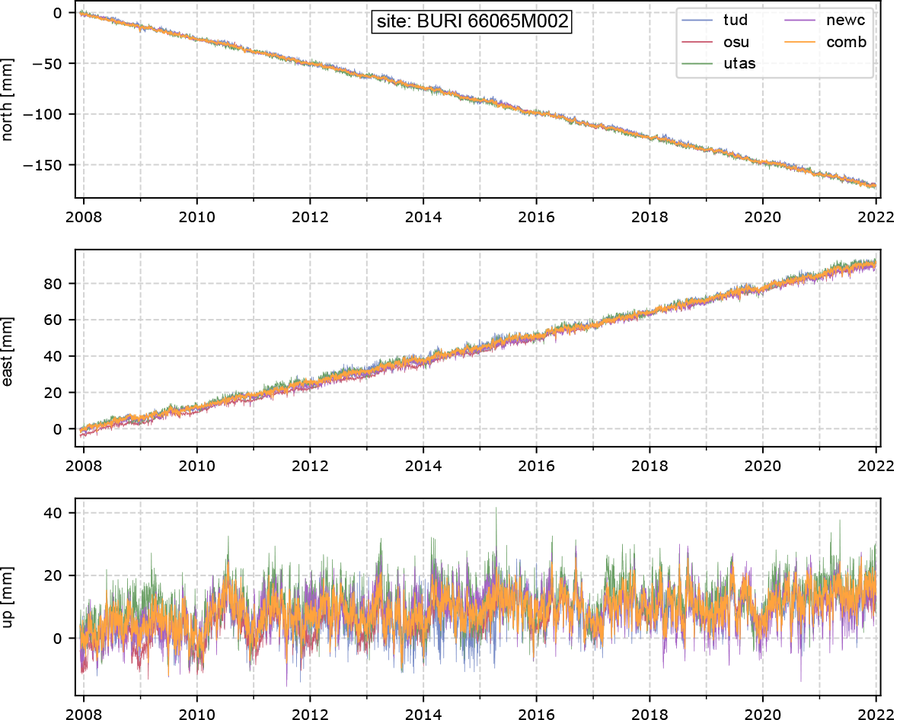
Koordinatenzeitreihe der Station Butcher Ridge (Transantarktisches Gebirge), v.o.n.u.: Nord-, Ost-, Vertikalkomponente
 © Sven Ellger
wiss. Mitarbeiter
NameDr.-Ing. Mirko Scheinert
Eine verschlüsselte E-Mail über das SecureMail-Portal versenden (nur für TUD-externe Personen).