15.03.2022
Wissenschaftler aus Deutschland und Argentinien erforschen klimabedingte Massenänderungen der Patagonischen Eisfelder

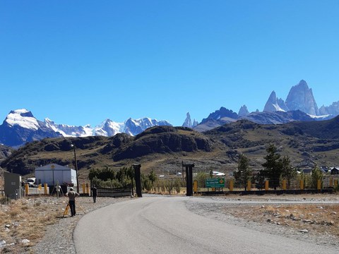
Nivellement zur Kontrolle der Höhenunterschiede zwischen den Messpunkten in El Chalten. Foto © Thorben Döhne (TU Dresden).
Jede und jeder kennt die Anekdote von Newton und dem Apfel. Da die Gravitation eine Wechselwirkungskraft ist, wird die Erde auch von dem Apfel angezogen. Damit ist klar, dass auch kleine Massenänderungen zu einer Veränderung des Schwerefelds führen.
Um diese kleinen Änderungen aufzuspüren, war ein Team aus deutschen und argentinischen Wissenschaftlern im südlichen Patagonien, in der argentinischen Provinz Santa Cruz unterwegs. Wissenschaftler der TU Dresden (TUD), des Bundesamts für Kartographie und Geodäsie (BKG) Leipzig, der Universidad Nacional de La Plata (UNLP) und des Argentine-German Geodetic Observatory (AGGO) haben die fünfwöchige Messkampagne Anfang März 2022 beendet und danach die mehr als 2.700 km lange Rückfahrt von El Calafate nach La Plata angetreten.
Im südlichen Patagonien, im Grenzgebiet zwischen Argentinien und Chile, befindet sich mit den Patagonischen Eisfeldern die größte zusammenhängende Eismasse auf der südlichen Hemisphäre außerhalb Antarktikas. Diese Eisfelder sind erheblichen Massenverlusten ausgesetzt, die größtenteils auf den Klimawandel, aber auch auf die natürliche Klimavariabilität und andauernde dynamische Ausgleichsvorgänge seit dem letzten glazialen Maximum zurückzuführen sind. Welche Anteile diesen verschiedenen Ursachen tatsächlich zugeschrieben werden können, ist eine der wichtigen offenen Fragen, zu denen aktuell geforscht wird und dieses Projekt einen Beitrag liefern soll. Diese Massenänderungen erreichen eine Größenordnung von bis zu einem Fünftel der Antarktischen Eismassenverluste und bewirken sowohl eine Veränderung des Schwerefelds als auch Deformationen der Erdkruste. Letztere äußern sich in einer Krustenhebung von bis zu 4 cm pro Jahr, ermittelt durch vorhergehende Messungen der TUD-Wissenschaftler. Erschwert wird die Detektion dieser resultierenden Änderungen aber durch eine komplizierte tektonische Situation: Ungefähr 150 km nordwestlich des Nördlichen Patagonischen Eisfelds treffen drei tektonische Platten aufeinander. Wo die divergente Plattengrenze zwischen der Antarktischen und Nazca-Platte unter die Südamerika-Platte subduziert, öffnet sich ein Asthenosphären-Fenster, was zu außergewöhnlichen, bisher nur unzureichend verstandenen Massenumverteilungen im Erdinneren führt.

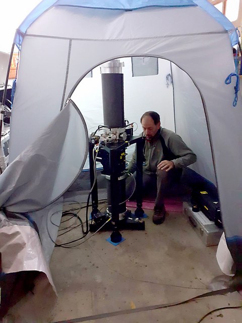
A. Pasquaré (AGGO) bei der absolutgravimetrischen Messung mit FG5, Messpunkt Glaciar Perito Moreno. Foto © Andreas Richter (UNLP).
Als wichtigste Größe wurde der Schwerewert an acht Messpunkten bestimmt, von der Atlantikküste in Puerto San Julian bis zum östlichen Rand des südpatagonischen Eisfelds mit dem Glaciar Perito Moreno als bekanntestem Gletscher. Dafür wurde ein Absolutgravimeter des Typs Micro-g LaCoste FG5 eingesetzt, mit dessen Hilfe es möglich ist, die Schwerebeschleunigung mit einer extrem hohen Genauigkeit von nahezu einem Milliardstel der Erdschwere zu bestimmen. Ergänzt werden diese Messungen durch Relativschweremessungen mit einem Scintrex CG5-Gravimeter zur Bestimmung von lokalen Schweregradienten und Anschlüssen an Sicherungspunkte bzw. Punkte des argentinischen Schwerenetzes (RAGA) sowie durch präzise GPS-Messungen zur Bestimmung der Krustendeformation.

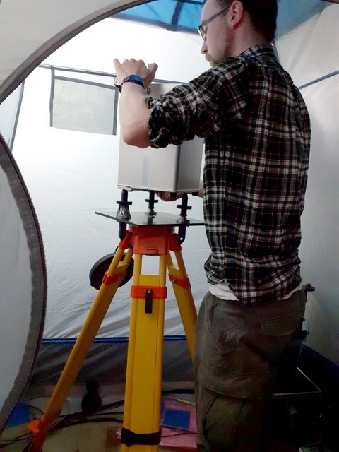
T. Döhne (TU Dresden) bei der Messung des Schweregradienten mit Relativgravimeter Scintrex CG5, Messpunkt Glaciar Perito Moreno. Foto © Andreas Richter (UNLP).
Eine Besonderheit stellen Wasserstandsmessungen mittels GPS-Reflektometrie an den großen patagonischen Seen und der Atlantikküste dar: Die indirekt empfangenen, an der Wasseroberfläche reflektierten Signale der GPS-Satelliten werden in der Auswertung dazu genutzt, die Höhe des Wasserspiegels und damit den Gravitationseffekt von Füllstandsänderungen des jeweiligen Gewässers zu bestimmen.

Aufbau der Ausrüstung zur GPS-Reflektometrie für die Bestimmung des aktuellen Wasserstandes des Lago Argentino. Foto © Andreas Richter (UNLP).
„Um die Schwereänderungen aufgrund der Massenverluste zu detektieren, ist nach dieser bereits zweiten mindestens eine weitere Messkampagne notwendig“, sagt Thorben Döhne, Doktorand an der Professur für Geodätische Erdsystemforschung, verantwortlich vor allem für die Relativschweremessungen. „Allerdings stellen die Wetterbedingungen, vor allem mit den heftigen, andauernden Winden, und die nicht immer einfachen logistischen Umstände, z.B. beim Transport von Mensch und Material über unbefestigte Straßen und Furten, besondere Herausforderungen an ein solche Messkampagne“, berichtet Andreas Richter, ehemals an der TU Dresden und nun an der UNLP tätig. Die Forscher hoffen, indem sie die absolut gemessenen Schwereänderungen und die mittels GPS bestimmten Krustendeformationen ins Verhältnis setzen, neue Einsichten in die Struktur des Erdinneren und die Natur der beobachteten Deformationsprozesse zu gewinnen. „Außerdem wird es helfen, die an der Erdoberfläche durchgeführten, also bodengebundenen Messungen mit satellitengeodätischen Messungen der Massenbilanz und Höhenänderung der Patagonischen Eisfelder zu verknüpfen“, ergänzt Döhne.
Das Forschungsvorhaben „Gravimetrische Bestimmung der Reaktion der festen Erde auf
Eismassenänderungen in Süd-Patagonien“ wird gemeinsam von Mirko Scheinert (TU Dresden) und Axel Rülke (BKG Leipzig) geleitet und von der Deutschen Forschungsgemeinschaft durch eine Sachbeihilfe finanziert.

Übersichtskarte über das Arbeitsgebiet mit dem Südlichen Patagonischen Eisfeld. Die Messpunkte der Absolutgravimetrie liegen sämtlich in der Provincia Santa Cruz, Argentinien. Karte © Mirko Scheinert (TU Dresden).
Dank
Die beteiligten Wissenschaftler bedanken sich ausdrücklich für die Unterstützung durch die Universidad Nacional de La Plata, Facultad de Ciencias Astronómicas y Geofísicas (Dekan: Prof. Raúl Perdomo), das Argentinisch-Deutsche Geodätische Observatorium (Wissenschaftlicher Direktor: Prof. Claudio Brunini), das Consejo Nacional de Investigaciones Científicas y Técnicas (CONICET) sowie das Instituto Geográfico Nacional (Direktor: Sergio Cimbaro).
Links
- Wissenschaftler aus Deutschland und Argentinien erforschen klimabedingte Massenänderungen der Patagonischen Eisfelder in der Newsübersicht News (/tu-dresden/newsportal/news)
- Professur für Geodätische Erdsystemforschung, TU Dresden:
https://tu-dresden.de/bu/umwelt/geo/ipg/gef - Bundesamt für Kartographie und Geodäsie (BKG): https://www.bkg.bund.de/
- Universidad Nacional de La Plata (UNLP), Facultad de Ciencias Astronómicas y Geofísicas: http://www.fcaglp.unlp.edu.ar/
- Argentine-German Geodetic Observatory (AGGO) – CONICET: https://www.conicet.gov.ar/the-future-of-geodetic-data-measurement-in-argentina/
- Instituto Geográfico Nacional (IGN): https://www.ign.gob.ar/
 © Sven Ellger
wiss. Mitarbeiter
NameDr.-Ing. Mirko Scheinert
Eine verschlüsselte E-Mail über das SecureMail-Portal versenden (nur für TUD-externe Personen).


