Finished Theses
Finished Master & Bachelor-theses
[Monitoring and analyzing land use/land cover and their changes using Remote Sensing and GIS in the Achamayo and Shullcas region, Peruvian Andes]
[Adaptation strategies of Andean campesinos to cope with the climatic variability - Examples from the Mantaro Valley, Peru]
[Socio-economic analysis of farm-forestry systems: Case studies from Achamayo and Palcazu watersheds, Peruvian Andes]
[Analysis of land use and land cover change in Cotapata National Park integrated management natural area, Bolivia]
[Non-farm and agricultural wage income in the Achamayo Region, Peru]
[Community based tree nurseries in the high Andes - A case study of the Achamayo sub-basin, Peru]
Monitoring and analyzing land use/land cover and their changes using Remote Sensing and GIS in the Achamayo and Shullcas region, Peruvian Andes
by Fernando Jakitsch Medina
Supervisors: Prof. Dr. Elmar Csaplovcis (Institute of Photogrammetry and Remote Sensing, TUD), Dr. Arief Wijaya (Department of Forest Biometry and System Analysis, TUD)
ABSTRACT: The availability of remote sensing and GIS (Geographical Information Systems) technologies enables advanced analysis of land use/cover. By examining past and current satellite imagery it is possible to determine trends and therefore estimate future conversions of land use. Thus, the assessment of land use and cover changes is an important tool for landscape evaluation and for speculating possible future scenarios. It is also useful for helping in the
development of management plans and policies to prevent future degradation of natural resources and to optimize land use.
The main objective of the project is to provide a description of the Achamayo and Shullcas region (Central Andes, Peru) by analyzing current and past land use/cover through remote sensing and GIS. The achievement of the objectives was done by analyzing two Landsat TM 5 images, one from 1985 and the other from 2010. The results showed that the area is very heterogeneous and has a patchy distribution of land uses, characteristics which are already reported for other Andean sites. The most dominant land cover is grasslands where livestock grazing is the main land use. It was found that there is a decrease on vegetation density of grasslands. These changes might be related to overgrazing and high erosion rates. Forest plantations are mostly formed by eucalypt trees. The increase detected in the study might be related to the reforestation projects carried out in the study area over the period of analysis. The current plantation cover is 20.98 km², representing 2.96% of the study site. It was also detected that some of these areas are missing a proper management. Urban areas have increased 17.81% from its original area over the period of analysis. The expansion took place in agricultural land which must be evaluated due to the importance of this activity in the area.
The harsh climatic conditions imposed by the altitude limit the land uses in the study area. Agriculture and forestry are concentrated in areas below the 4000 m a.s.l.. The topography is also related to land uses in other ways. It was detected that, since tree plantations is preferably established in marginal areas (not suitable for agriculture), they were mostly located in steep slopes. Moreover, relief can also protect areas at high altitudes from climatic events (e.g. frosts and winds) thus allowing agricultural cultivation higher than 4000 m. This thesis provides a description of the land use/cover in the area and points out the changes experienced since 1985. The need for management interventions in plantations is recommended for a yield increase and further evaluation of other land cover types such as grassland and bofedales are indicated.

Land use/land cover change map
Adaptation strategies of Andean campesinos to cope with the climatic variability - Examples from the Mantaro Valley, Peru
by Gregory Amos
Supervisors: Dr. Sergio A. Ruiz (Professorship of Tropical Forestry, TUD), Dr. Mario E. Tapia (National Agrarian University La Molina, Lima)
ABSTRACT: The central Andes have always been a region of large climatic variability, and small farmers (or "campesinos") have developed over centuries strategies to cope with these variations. The adaptation strategy to the climatic hazards of Andean campesinos can be integrated in a framework consisting in forecast, dispersion and mitigation of the risk. An holistic adaptation strategy should include all of them. For each of these three elements, a range of specic strategies and technologies can be applied.
The climate in the Andean region is changing, this means that the natural climatic variability is becoming more extreme, with stronger frosts, longer droughts or more intensive rainfalls. The Andean campesinos can still take advantage of the usually applied adaptation strategies to cope with the new climatic patterns, but their effectivity in this new context is still unclear.
This master thesis identies the adaptation strategies used by campesinos in the central part of the Mantaro Valley, compares them with past and/or regional practices, and identifies which of them are loosing their effectiveness in front of the new climatic variability.

Crop protection by terraces, tree fences and stone walls (Artist: Mario Villalva, MINKA magazine 1989)
Socio-economic analysis of farm-forestry systems: Case studies from Achamayo and Palcazu watersheds, Peruvian Andes
by Claudia Zuleta del Solar
Supervisors: Prof. Dr. Jürgen Pretzsch (Professorship of Tropical Forestry, TUD), Dr. Maria De Los Angeles La Torre Cuadros (Department of Forest Management, National Agrarian University La Molina, Lima)
ABSTRACT: Adaptation to Andean ecosystems has developed over generations. This has resulted in various, small scale farming systems extending widely throughout Peru. This systems form the basis of the local population’s livelihood, provide a useful means for recovering, conserving and increasing biodiversity. However, climatic changes are likely to exacerbate the risks and even reduce potential yields.
The present research aims to enhance the important role of farm forestry systems for small farmers’ livelihoods in two areas considered vulnerable to climate change. With a holistic approach, Farming Systems Research (FSR) with a livelihood focus is used to carry out a socio-economic analysis of small farm-household systems in Achamayo and Palcazu watersheds. It follows an exploratory, multiple-case embedded design in which two levels can be distinguished: watershed and farm household. The watersheds are part of the surrounding context in which embedded units of analyses (households) have been identified and significant data have been collected for each case.
In Achamayo, 63 household interviews were conducted in the campesino communities of San Antonio, La Florida, La Libertad, San Pedro and Santiago de Marcatuna. In Palcazu, 13 household interviews were conducted in three sectors of the amuesha community of Tsachopén: Miraflores, Gramazú and Sipizú. Furthermore, group interviews, tree-preference rankings, key informant interviews, direct observation and revision of secondary data have been conducted to increase validity and reliability of findings.
The description of socio-economic and cultural aspects; political and institutional factors; farm forestry systems and perceptions towards trees is presented for each case study area. Furthermore, a comparative analysis and discussion brings together the main findings and provides answers to the research questions.
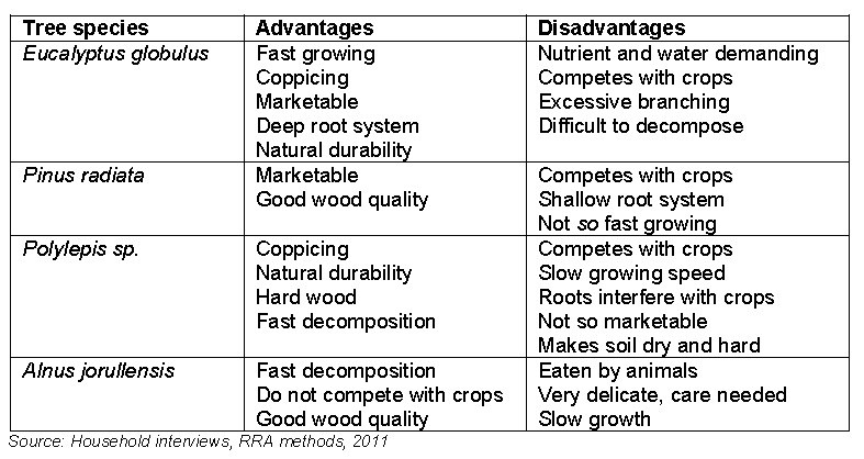
Advantages and disadvantages of tree species as percieved by local farmers
Analysis of land use and land cover change in Cotapata National Park integrated management natural area, Bolivia
by Daniela Limache de la Fuente
Supervisors: Prof. Dr. Elmar Csaplovcis (Institute of Photogrammetry and Remote Sensing, TUD), Dr. Arief Wijaya (Department of Forest Biometry and System Analysis, TUD)
ABSTRACT: Understanding the dynamics of land-use and land-cover change (LULC) is one of the key concepts on many urgent issues like global climatic change, food security, and loss of biodiversity, soil degradation, hydrology and even human well-being. The processes and factors associated with it are very complex, resulting from the interaction of human-environment systems which are influenced by environmental, socioeconomic, policy and institutional drivers. On the Bolivian mountain zones, the landscape has been shaped mainly through the agriculture by local peasants and immigrants. One the most relevant examples of the dynamic of LULC is the Cotapata “National Park and Integrated Management Natural Area (NP-IMNA), which presents a vertical transition from the Andean zones through the lowlands and where the pattern of the land use and land cover has changed dramatically since the pre-colonial era until today. In this sense, the aim of the present study was to implement a geographical approach focused on Huarinilla watershed, that considers the explicit patterns of LULC during 1987 and 2010, appealing to remote sensing techniques and identify some causes or main driving forces using questionnaires and field observations.
A current land use and land cover was mapped into nine classes with an overall accuracy of 85.33% and Kappa coefficient of 0.83. For the image corresponding to 1987, the results showed an overall accuracy of 80.68% and Kappa coefficient of 0.77. In the study area can be evidenced two main characteristics of the land use and land cover classes: a patchy distribution along Huarinilla river edges and its affluents, and an altitudinal distribution, which is more evident since 2500-3000m. The change detection analysis indicated that „mountain forest‟ is the most dominant class, representing approximately 49.78% of the total area of Huarinilla watershed (49287 ha) and since 1987 has experienced an increase of 4.46%. This increase might be related to the new management in the park; inaccessibility for agricultural purposes due to the steep topography and the marginal areas, and finally the reduction of forest exploitation due to migration of population from settlements and communities to nearest cities and towns. Furthermore, it was noticed a significant decrease on vegetation density of „shrublands‟ and „open forest‟ in contrast with an increase of „grasslands‟. These changes might be related to the long forest exploitation by local communities (i.e. firewood and construction material) before the establishment of the park and the high erosion rates, considered an important factor of degradation of these ecosystems, during the wet season. Equally important, is the reduction of Bofedales (HAWAs) and permanent snow. Although the causes of this diminution are not determined, it assumed a close link between both dynamics of change.

Cloud forest in the Cotapata National Park at 1700m asl.
The potential impact of an altered temperature regime on specific agricultural vegetation formations in the Peruvian Central Andes - a model study
by Johannes Drechsel
Supervisors: Prof. Dr. Elmar Csaplovcis (Institute of Photogrammetry and Remote Sensing, TUD), Prof. Dr. Uta Berger (Professorship in Forest Biometrics and Systems Analysis, TUD)
ABSTRACT: Temperature is one of the most important abiotic factors influencing plant growth. Most of future scenarios for climate change expecting an overall rise in temperature. Nevertheless an increase of extreme weather events like frosts is more likely at the same time. Hence the consequences of climate change for agriculture are still unsure. In this context the objective of present work was to estimate the impacts of changing temperatures on the local distribution of the most important cultivars and trees in the Achamayo water catchment
As a first step land-cover and land-use maps were elaborated to represent the current situation in the research area. Furthermore the characteristics in terms of temperature requirements and potential current and future distribution of Solanum tuberosum, Solanum spec., Ullucus tuberosus, Zea mays amylaceae, Lolium perenne, Polylepis incana and Eucalyptus globulus were elaborated for the research area. Based on high resolution RAPIDEYE satellite images a supervised classification was executed. The generated classes were used to determine the suitability of the sites for respective plant growth. Using a model of temperature distribution from the Geophysical Institute of Peru (IGP), the potential current distribution of the cultivars and trees was estimated based on their tolerance of temperature. Therefore the species were divided into two groups. The first group consists of cultivars which grow only temporal like Solanum tuberosum, Solanum spec., Ullucus tuberosus and Zea mays amylaceae, while the second group represents species with an annual growth like Lolium perenne, Polylepis incana and Eucalyptus globulus. For species with temporal growth the average of the maximum and minimum temperature of each month of the growing season was used, whereas annual plants were characterized by the mean annual temperature. Since the exact trend in climate change is unknown, the model considers two contrary scenarios for temperature development until the year 2015. The first scenario assumes a decrease of the mean annual temperature by 1,5°C and for the maximal and minimal temperature per month by 2°C and 3°C. In contrast to this shows the second scenario an increase in temperature by 1,3°C for mean annual and maximal / minimal temperature. But since plant growth in the research area is only limited by the minimal temperature and not by maximal temperature, only the upper borderline for each species was determined. Under current site conditions the largest area of distribution (105,64 km²) of all cultivars in the catchment belongs to the native potato (Solanum spec.). It can be cultivated up to 4200m altitude. More thermophile plants like Zea mays amylaceae grow only up to 3450m. Hence their area of distribution ranges only to 19,7 km². Regarding the investigated tree species, the native Polylepis incana has the greatest area of distribution which reaches up to 4150m and covers 95,4 km². The results of the model study show a clear influence of changing temperature regimes on the area of distribution as well as on the upper borderline of all investigated plants. Therefore decreasing temperatures lead to lower borderlines and to drastically reduction of suitable sites for cultivars and trees. Beside of Solanum spec. all cultivars would diminish from the research area because of low temperatures. The borderline of the annual plants would be decline by 200m in connection with a loss of suitable sites of 37%. On the opposite, rising temperatures cause an expansion of the upper borderlines and potential areas of distribution. Species with temporal growth are expected to expand their habitat by 92%, while the borderline moves 290m up. The expansion of the annual plants like Lolium perenne, Eucalyptus globulus and Polylepis incana is expected by 180m upwards. This means an expansion of suitable sites by 45%. But beside all positive effects like an expansion of potential growing sites there are also negative impacts connected to higher temperatures such as invasion and expansion of diseases and pests. Also drought stress and absence of precipitation could lead to losses in yield.

Satellite image showing a small scale mosaic of agricultural land
Non-farm and agricultural wage income in the Achamayo Region, Peru
by Nicolás Wittmann
Supervisors: Prof. Dr. Jürgen Pretzsch (Professorship of Tropical Forestry, TUD), Dr. Sady J. Garcia Bendezu (Institute of Soil Sciences, National Agrarian University La Molina, Lima)
ABSTRACT: The majority of the rural population in Latin America is characterised by poverty. Rural households pursue different livelihood strategies in order to escape this poverty. One important path is income diversification. In the case of small scale farmers, farm incomes are often complemented by off-farm incomes. These may stem from non-farm employments or agricultural wage employments. This thesis explores the off-farm activities of small scale farmers in three case study communities in the Achamayo region. The region is situated in the central Peruvian Andes on the slope of the Mantaro Valley. The assessment covers the off-farm sector itself as well as an analysis of factors leading to households’ engagement in off-farm activities.
Off-farm labour is very common in the study area. More than 70% of all interviewed households engage in some form of off-farm activity. Although a similar number of households engage in non-farm labour as in agricultural wage labour, much more time is invested in the former. One reason is that, in average, non-farm labour is three times more profitable than agricultural wage labour. The study area itself however, is relatively poor in non-farm employment opportunities. The majority of farmers engaging in such activity commute to nearby urban centres or by temporarily migrating to other areas.
A number of factors “push” households away from subsistence agriculture. An ongoing change in values increases farmers need for cash income. Improved education and technical gadgetry are example of these needs. Changing markets and limitations given by difficult site conditions allow only few households to satisfy their needs by their farm income alone. Especially large households whose head is well educated engage in off-farm activities in order to increase their income. Also the availability of credits coincides strongly with the engagement in off-farm labour. Factors “pulling” households towards income diversification in the area are the proximity to urban markets and the need to compensate for yield losses after extreme weather events. Also, the off-farm sector offers flexible employment in seasons where there is little demand for own-farm work.

Community in the Achamayo watershed
Community based tree nurseries in the high Andes - A case study of the Achamayo sub-basin, Peru
by Philipp Lethen
Supervisors: Prof. Dr. Martin Welp (Chair of Socioeconomics and Communication, Eberswalde University for Sustainable Development), Dr. André Lindner (Professorship of Tropical Forestry, TUD)
ABSTRACT: The population of the Andean Mountains of Peru has ever since been facing rapid climatic changes and extreme weather events. The development of adaptation strategies was essential for the population to survive under harsh living conditions. In order to cope with climatic extremes, agro-forestry systems were developed as measures to protect agricultural crops. Today, as a consequence of anthropogenic climate change, extreme weather events such as frosts, hail, intense rainfalls and strong winds occur more frequently. In the Andean mountains seasons seem to be shifting, which makes weather less predictable and thus the periods of sowing more difficult to determine. “Cercos Vivos” or “living circles” are one traditional measure to protect crops from weather influences. Trees are planted as circles around the parcels to protect the crops from frosts, hail, intense rain and wind and also to prevent erosion. Cercos Vivos serve as fencing against animals and, furthermore, the wood obtained from the trees is used as fuel or construction wood. Research on traditional adaptation measures is an important factor in developing and transferring strategies to reduce the impacts of climate change and the vulnerability of the Andean population.
This bachelor thesis focuses on rural communities located in the Achamayo sub-basin, Peru. Members of the communities are participating in community tree nurseries, which are managed by the state-owned organization AgroRural. In recent years, however, communities reduced their participation significantly. As reforestation is an important measure to reduce the impacts of extreme weather events and accordingly the tree nursery project is a measure to raise the adaptive capacity of the community members, it was considered important to find out the reasons for the decreasing participation.
In this Bachelor thesis, some results from social research in the communities, using qualitative as well as quantitative research methods, shall be presented.
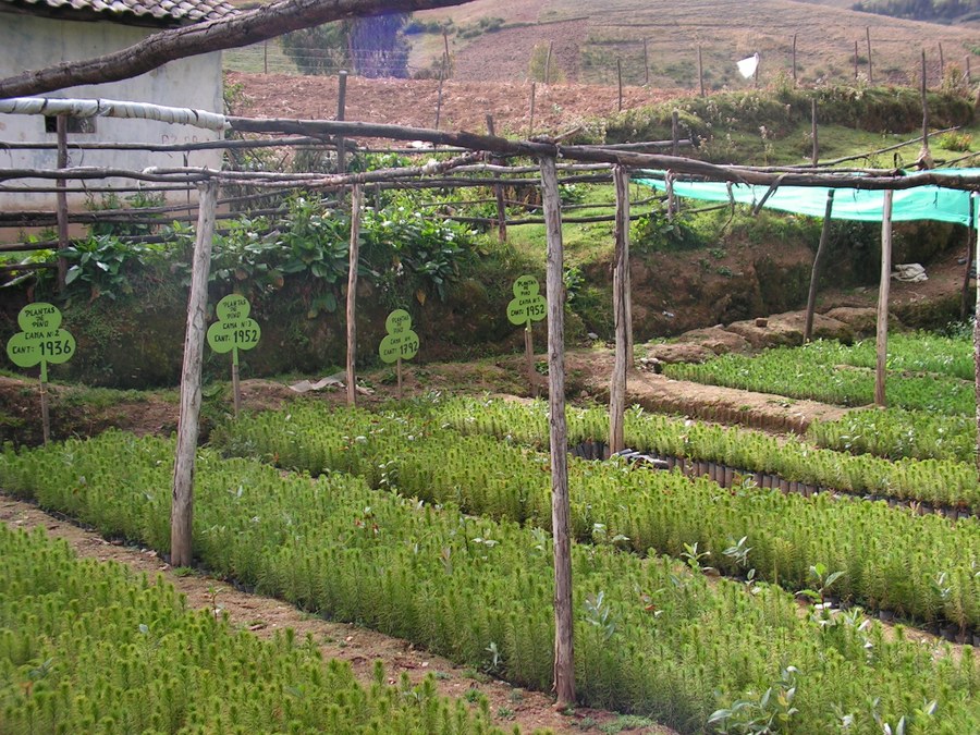
Tree nursery with Pine seedlings
Land use and land cover change: a temporal analysis using remote sensing and GIS in the Central District of Inquisivi Municipality, La Paz, Bolivia
by J. Omar Torrico Sejas
Supervisors: Prof. Dr. Elmar Csaplovcis (Institute of Photogrammetry and Remote Sensing, TUD), Dr. André Lindner (Professorship of Tropical Forestry, TUD)
ABSTRACT: Worldwide land use and land cover change (LULC) is the result of natural and anthropogenic forces. They provoke different alterations to the natural landscape, impacting the ecosystem services, resulting in biodiversity loss and soil degradation. In the case of the Andean region, ecosystems are highly vulnerable to human activities and climatic factors, which have a strong influence on shifting vegetation and hydrologic regimes. Hence, LULC change is one of the most important ecological challenges faced by society and rural communities, where most of the inhabitants are subsistence farmers, using traditional agricultural practices adapted to these sensitive environment.
Understanding the dynamics of change constitutes a key component in climate change assessments, since it is possible that local communities are adapting their land management in response to climate variability. This master thesis was designed under the frame of the international network of climate change adaptation (INCA), and intends to contribute with information regarding LULC changes in the central district of Inquisivi Municipality, an area of special interest due to its social, cultural and natural diversity (Biocultural area). A multi-temporal analysis of satellite images for the periods 1986-1998 and 1998-2011, was carried out, which characterized and quantified the past and current dynamics of change in the study area.
The results have confirmed the high importance to conduct pre processing corrections in mountainous areas images in order to make them suitable for LULC analysis. Eight different classes were described, with the dominant categories: Dense vegetation, Shrubland/sparse vegetation, Agriculture, Grassland, Plantation/mixed vegetation and Bare land. These classes have experienced different trajectories of change in the past 25 years, and it was perceived that land use/cover have been altered by human activities, mostly related to agricultural and forestry practices. It was also found a reduction of Dense vegetation and Agriculture, while Plantation/mixed vegetation and Shrubland/sparse vegetation have increased during these periods.

Linkages between human driving forces and land cover.
Understanding the role of forest environmental income in the livelihood of rural households living adjacent to Chiquitano dry forest area in Bolivia
by Rosa Elena Estévez Montalván
Supervisors: Prof. Dr. Jürgen Pretzsch (Professorship of Tropical Forestry, TUD), Dr. Elizabeth Jiménez Zamora (Graduate Program in Social Sciences CIDES, Universidad Mayor de San Andres, La Paz)
ABSTRACT: Chiquitano Dry Forest is an ecoregion characterized by its transitional location between the humid climate of the Amazon and the arid Chaco. It is a deciduous and semi-deciduous forest, which represents the largest remaining well-preserved Dry Forest area worldwide. However, it is also one of the most threatened ecosystems in the Neotropics due to the different threats, mostly resulting from human activity, such as the expansion of the agricultural frontier and livestock. Chiquitano Dry Forest provides a variety of resources, such as: timber and non-timber forest products, medicinal plants, animal food, etc. However, timber supply is one of its main services. Due to the large amount of hardwood, this forest is considered one of the most economically valuable Bolivian forests.
The research was conducted in 15 de Agosto, which belongs to San Ignacio de Velasco township, in Chiquitania region of Santa Cruz Department. The community forms part of the set of “Campesino Communities” in Bolivia with an already completed titling process. Under this type of land property, the Constitution recognizes the exclusive use of renewable natural resources, benefit sharing from the exploitation of nonrenewable natural resources, the faculty of applying their own rules and the definition of development according to their culture. The community´s adjacent forest area is characterized by valuable timber species. It is so from 2004, villagers develop community forestry.
In this regard, the research aims to understand the contribution expressed in monetary value of forest resources to community´s households. It seeks to answer some questions such as: What is the role of forest environmental income in the livelihood of community’s households?, What is the distribution of forest environmental income between higher income and lower income household groups?, What is the relationship between forest environmental income and the different households’ features?, and finally, how has the ownership regime influenced forest benefits? The methodology developed by PEN-Network was followed for data collection and analysis.
Dimensions of the forest-poverty link