Environmental Remote Sensing at TU Dresden
The Professorship in Environmental Remote Sensing is representing remote sensing as an integrative environmental discipline at TU Dresden.


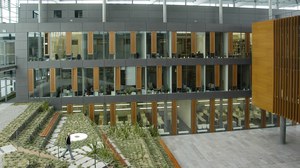
 © M. Forkel
Environmental Remote Sensing at TU Dresden
The Chair of Environmental Remote Sensing (since September 2025) was newly created as a Junior Professorship in September 2019. We teach and understand remote sensing as an integrative environmental science at TU Dresden. The Chair is held by Matthias Forkel.
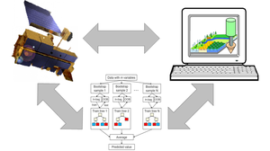
The Chair's core research areas are the development of methods and application of satellite data and derived products for the observation, analysis, modeling and prediction of changes in ecosystems and their influence on the global carbon and water cycle and the climate. Another core research area is the observation and prediction of vegetation fires. We use and develop data-based methods of time series analysis, machine learning, artificial intelligence, environmental parameter estimation, process-based environmental modeling and model-data integration techniques. Research
The Chair offers courses in the Bachelor's degree programs Environmental Informatics, Geodesy and Geoinformation and Geography as well as in the Master's degree programs Geoinformation Technologies, Geodesy, Cartography, Forest Sciences and Tropical Forestry. The focus of teaching is on imparting knowledge at the interface between remote sensing (sensors, data, methods), environmental research (carbon and water cycle, climate change) and data science (statistics, time series analysis, image processing, machine learning). Teaching