Courses
Table of contents
The junior professorship is offering classes in the studies BSc Geography, BSc Geodesy and Geoinformation, MSc Geography, MSc Geoinformation technologies, MSc Geodesy, MSc Cartography and MSc Tropical Forestry. Responsible is Prof. Dr. Matthias Forkel.
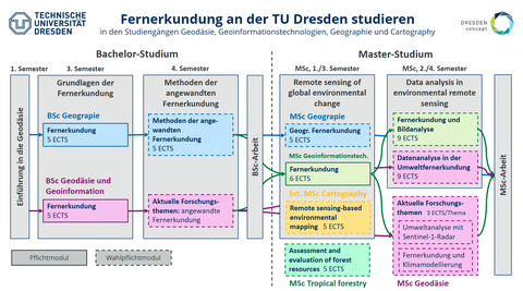
![Modules of environmental remote sensing](https://tu-dresden.de/bu/umwelt/geo/ipf/envrs/ressourcen/bilder/forkel_fernerkundung-module_tud_v2022.png/@@images/21afbf9c-2739-4fc6-82f2-1a5d971d3109.png)
You can study environmental remote sensing within the studies of Geography, Geodesy, Geoinformation technologies and Cartography.
Winter semester 2024/2025
Remote Sensing of Environment and Climate (and Forests)
MSc GIT 04: Fernerkundung (MSc Geoinformationstechnologien)
MSc-Cart-6: Remote sensing-based environmental mapping (MSc Cartography)
UWFMF01A: Fernerkundung und Datenanalyse (MSc Forstwissenschaften, Teil Fernerkundung)
Inscription and material in Opal
The lecture will be held in English and consists mostly of input video and joint discussions.
Dates
-
Wednesday 13:00-14:30 - HÜL/S590 - Exercise for MSc GIT, MSc Cartography
-
Thursday 11:10-12:40 - SCH/A118 - Lecture (only selected dates for MSc Forstwissenschaften)
-
Friday - Exercise for MSc Forstwissenschaften (individual dates)
First date
-
Introduction: 17. Oktober 2024, 14:50-16:20 - SCH A 118
Studiengänge:
- BSc Geodäsie: UW-B-GG-13
- BSc Geographie UW-BGEO-10
Start: 17. October 2024, 11:10, SCH A316
Details in Opal
Studiengänge:
- BSc Geodäsie: UW-B-GG-01
- Details in Opal
The module is held together with the Chair of Forest Growth and Woody Biomass Production
Inscription and material in Opal
Study: MSc Tropical forestry, module FOMT1.4B (Assessment and evaluation of forest resources)
Dates for the remote sensing parts of the module:
- 11.11.2024 - Introduction to remote sensing and global environmental change
- 28.11.2024 - Remote sensing of light absorption, phenology and photosynthesis
- 09.12.2024 - Remote sensing of biomass and land cover
Project Environmental Remote Sensing I + II
Current methods of machine learning for environmental monitoring
Current topics / Advanced methods of optical and microwave remote sensing for ecology, forest fire and climate research
Course enrollment, information and material in OPAL
Informations
- Degree program
- BSc Geographie: UW-GeoB-570 Aktuelle Verfahren des maschinellen Lernens für Umweltmonitoring (einmalig im WS 2024/2025)
- MSc Geodesy: UW-M-G-07 Current Research Topics in Geodesy: Environmental Remote Sensing
- Course director: Prof. Dr. Matthias Forkel
- Project supervision: Staff of the Junior Professorship for Environmental Remote Sensing
- Seminar: The seminar is the colloquium for environmental remote sensing, which takes place every Thursday at 09:20.
- Introduction date and assignment of topics: October 17 2024, 09:20 - 10:50 , BAR-186C
Summer semester 2024
Data analysis in environmental remote sensing
Course enrollment, information and material in OPAL
- First date: 10.04.2024, 13:00-14:50, HÜL-590
- Lecture language: English (German possible if all participants are German-speaking)
- Examination language: German or English at choice
The module consists of two parts:
Seminar: "Retrieval of land surface parameters in the optical and microwave domain"
- Leader: Prof. Dr. Matthias Forkel
- approx. every two weeks on Thursday 14:50-16:20 and as a block seminar on June 26/27 and July 03/04
- Examination: Seminar paper
Lecture and exercise: "Image analysis, machine learning and deep learning in remote sensing"
- Lecturers: Eric Kosczor, Lucas Kugler, Daniel Kinalczyk
- Examination: oral examination
Module description
Qualification goals | Students are familiar with methods of multivariate analysis of optical and microwave remote sensing data for mapping land cover and biogeophysical land surface parameters. They are able to describe, apply and critically evaluate the methods of image analysis, unsupervised and supervised classification, machine learning, deep learning and inversion of radiative transfer models as well as to use and adapt the corresponding programming languages and software packages. |
Contents |
Contents of the module are processing and analysis of multispectral and radar satellite data, filtering, texture, methods of land cover classification, machine learning and deep neural networks for classification and regression, radiative transfer models, methods of model inversion and derivation of land surface parameters. |
Teaching and forms of learning |
2 SWS lecture, 2 SWS (extended) seminar, 1 SWS exercise, self-study. The courses are mainly held in English. The language of instruction (German or English) will be announced before the start of the semester. |
Prerequisites for participation | Basic knowledge of the physical principles of remote sensing as well as the basic analysis of multispectral satellite data and univariate and bivariate descriptive statistics at Bachelor's level is required. |
Applicability | The module is one of 10 compulsory elective modules in the Master's degree program in Geodesy, 5 of which must be selected, and one of 8 compulsory elective modules in the Master's degree program in Geoinformation Technologies, 5 of which must be selected. |
Requirements for the awarding of credit points | Credit points are awarded if the module examination is passed. The module examination consists of an oral examination lasting 20 minutes and a seminar paper lasting 60 hours. The examinations can also be taken in English by documented arrangement. |
Credit points and grades | The module is worth 9 credit points. The module grade is calculated from the unweighted average of the grades of the individual examinations. |
Frequency of the module |
The module is offered every summer semester. |
Workload | The total workload is 270 hours . |
Duration of the module | The module lasts one semester. |
Project Environmental Remote Sensing I + II
Current topics / Advanced methods of optical and microwave remote sensing for ecology, forest fire and climate research
Course enrollment, information and material in OPAL
Informations
- Degree program MSc Geodesy: UW-M-G-07 Current Research Topics in Geodesy: Environmental Remote Sensing
- Course director: Prof. Dr. Matthias Forkel
- Project supervision: Staff of the Junior Professorship for Environmental Remote Sensing
- Seminar: The seminar is the colloquium for environmental remote sensing, which takes place every Thursday at 11:10.
- Introduction date and assignment of topics: April 11, 2024, 11:10 - 12:00, HÜL-442
Course enrollment, information and material in OPAL
Course management
- Contact person: Dr. Christine Wessollek
- Lectures: Prof. Dr. Matthias Forkel, Dr. Christine Wessollek
Degree programs
- BSc Geography: UW-BGEO-GI4 (Methods of applied remote sensing)
- BSc Geodesy: GG 20 (Current research topics)
Dates
- First date: 11.04.2024, 9:20-10:50, SCH-A118
- Please note the exact course schedule in Opal!
Winter semester 2023/2024
"Remote Sensing of Global Environmental Change"
MSc GIT 04: Fernerkundung (MSc Geoinformationstechnologien)
UW-M-GEO-K5: Geographische Fernerkundung (MSc Geographie)
MSc-Cart-6: Remote sensing-based environmental mapping (MSc Cartography)
Inscription and material in Opal
The lecture will be held in English and consists of input video and joint discussions. The exercise and seminar will be in English for the MSc Cartography and in German for the other studies. The exam will be bilingual and can be done in English or German.
Dates
-
Wednesday 11:10-12:40 and 13:00-14:30 - HÜL/S590 - Lecture and exercise
-
Thursday 11:10-12:40 - SCH/A01 - Lecture (not at every Thursdays)
First date
-
Introduction: 18. October 2023, 11:10 - 12:40 - HÜL/S590
Studiengänge:
- BSc Geodäsie: UW-B-GG-13
- BSc Geographie UW-BGEO-10
Start: 12 October 2023, 11:10, SCH/A316
Details in Opal
Studiengänge:
- BSc Geodäsie: UW-B-GG-01
- BSc Geographie UW-BGEO-04
Termine:
- Introduction: 11 October 2023, 13:00, HÜL/S186
- Details in Opal
The module is held together with the Chair of Forest Growth and Woody Biomass Production
Inscription and material in Opal
Study: MSc Tropical forestry, module FOMT1.4B (Assessment and evaluation of forest resources)
Dates for the remote sensing parts of the module:
- Montag 09:45 - 11:30 und 12:30 - 15:30
- 06.11.2023 - Introduction to remote sensing and global environmental change
- 27.11.2023 - Remote sensing of light absorption and phenology
- 18.12.2023 - Remote sensing of biomass and land cover
- 08.01.2024 - Joint exercise forest growth + remote sensing(?)
- Studiengang: MSc Geodäsie
- Modul: UW-M-G-07 Aktuelle Forschungsthemen der Geodäsie: Umweltfernerkundung
- Projekt: Integration von Fernerkundung und Klimamodellierung
Kurseinschreibung, Infos und Material in OPAL
Termine
- Erster Termin: 12. Oktober 2023
- Siehe Kursplan in Opal
- Seminar: Donnerstag, 13:00 - 14:30, TIL/S05
Summer semester 2023
Data analysis in Environmental Remote Sensing / Datenanalyse in der Umweltfernerkundung
Kurseinschreibung, Infos und Material in OPAL
Kursleitung
- Verantwortlich, Seminar: JProf. Dr. Matthias Forkel
- Vorlesungen: Dr. Christine Wessollek, Luisa Schmidt (MSc), Lucas Kugler (MSc), Eric Kosczor (MSc)
Studiengänge
- MSc Geoinformationstechnologien: MSc GIT 09 (Fernerkundung und Bildanalyse)
- MSc Geodäsie: UW-M-G-11 (Datenanalyse in der Umweltfernerkundung)
Termine
- Erster Termin: 05. April 2023, 13:00 – 14:30 (4. DS), HÜL/S590
- Termine:
- Mittwoch, 13:00 - 14:30 (4. DS), HÜL/S590 (Vorlesungund/oder Übung)
- Mittwoch, 14:50 - 16:20 (5. DS), HÜL/S590 (Übung)
- Donnerstag, 11:10 – 12:40 (3. DS), SCHU/A01 (Vorlesung oder Seminar)
- Bitte den genauen Semesterplan in Opal beachten!
Projekt: Umweltanalyse mit Sentinel-1-Radar-Daten
Kurseinschreibung, Infos und Material in OPAL
Kursleitung
- Verantwortlich: JProf. Dr. Matthias Forkel
- Vorlesungen und Seminar: JProf. Dr. Matthias Forkel, Johanna Kranz (MSc), Xiao Liu (MSc)
Studiengang
- MSc Geodäsie: UW-M-G-07 Aktuelle Forschungsthemen der Geodäsie: Umweltfernerkundung
Termine
- 1. Veranstaltung: 06. April 2023, 14:50 - 16:20 (5. DS), TIL S05
- Seminar: Donnerstag, 14:50 - 16:20 (5. DS), TIL S05
Kurseinschreibung, Infos und Material in OPAL
Kursleitung
- Ansprechperson: Dr. Christine Wessollek
- Vorlesungen: JProf. Dr. Matthias Forkel, Dr. Christine Wessollek
- Seminar: Dr. Christine Wessollek
Studiengänge
- BSc Geographie: UW-BGEO-GI4 (Methoden der angewandten Fernerkundung)
- BSc Geodäsie: GG 20 (Aktuelle Forschungsthemen)
Termine
- Erster Termin: 06.04.2023, 11:10-12:40, TIL S05
- Vorlesung/Übung: Donnerstag, 11:10 - 12:40 (3. DS), TIL S05 - BSc Geographie + BSc Geodäsie und Geoinformation
- Seminar: Donnerstag, 09:20 - 10:50 (2. DS), SCH/A118 - nur für BSc Geographie
- Bitte beachten Sie den genauen Kursplan im Opal!
Winter semester 2022/2023
"Remote Sensing of Global Environmental Change"
MSc GIT 04: Fernerkundung (MSc Geoinformationstechnologien)
UW-M-GEO-K5: Geographische Fernerkundung (MSc Geographie)
MSc-Cart-6: Remote sensing-based environmental mapping (MSc Cartography)
Inscription and material in Opal
The lecture will be held in English and consists of input video and joint discussions. The exercise and seminar will be in English for the MSc Cartography and in German for the other studies. The exam will be bilingual and can be done in English or German.
Dates
-
Lecture (in English for GIT + Geographie + Cartographie) - Thursday 11:10-12:40 - HÜL/S186
-
Exercise
-
in German (mainly for GIT + Geographie) - Wednesday 11:10-12:40 - HÜL/S590
-
in English (mainly for Cartography) - Wednesday 13:00-14:30 - HÜL/S590
-
First date:
-
Introduction for MSc GIT und MSc Geographie: 19. October 2022, 11:10 - HÜL/S590
- Introduction for MSc Cartography: 19. October 2022, 13:00 - HÜL/S590
The module is held together with the Chair of Forest Growth and Woody Biomass Production
Inscription and material in Opal
Study: MSc Tropical forestry, module FOMT1.4B (Assessment and evaluation of forest resources)
Dates for the remote sensing parts of the module:
- Montag 10:00 - 11:30 und 12:30 - 15:30
- 07.11.2022 - Introduction to remote sensing and global environmental change
- 28.11.2022 - Remote sensing of light absorption and phenology
- 19.12.2022 - Remote sensing of biomass and land cover
- 09.01.2023 - Joint exercise forest growth + remote sensing
- Studiengang: MSc Geodäsie
- Modul: UW-M-G-07 Aktuelle Forschungsthemen der Geodäsie: Umweltfernerkundung
- Projekt: Integration von Fernerkundung und Klimamodellierung
Kurseinschreibung, Infos und Material in OPAL
Termine
- Erster Termin: 12. Oktober 2022
- Siehe Kursplan in Opal
- Seminar: Donnerstag, 13:00 - 14:30, TIL/S05
Summer semester 2022
Data analysis in Environmental Remote Sensing / Datenanalyse in der Umweltfernerkundung
Kurseinschreibung, Infos und Material in OPAL
Kursleitung
- JProf. Dr. Matthias Forkel, Luisa Schmidt (MSc), Lucas Kugler (MSc)
Studiengänge
- MSc Geoinformationstechnologien: MSc GIT 09 (Fernerkundung und Bildanalyse)
- MSc Geodäsie: UW-M-G-11 (Datenanalyse in der Umweltfernerkundung)
Termine
- Erster Termin/First date: 06. April 2022, 13:00 – 14:30 (4. DS), HÜL/S590
- Vorlesung: Donnerstag, 11:10 – 12:40 (3. DS), SCHU/A01
- Seminar: Mittwoch, 13:00 - 14:30 (4. DS), HÜL/S590
- Übung/Tutorim: Mittwoch, 14:50 - 16:20 (5. DS), HÜL/S590
Projekt: Umweltanalyse mit Sentinel-1-Radar-Daten
Kurseinschreibung, Infos und Material in OPAL
Kursleitung
- JProf. Dr. Matthias Forkel, Konrad Bauer (MSc), Xiao Liu (MSc)
Studiengang
- MSc Geodäsie: UW-M-G-07 Aktuelle Forschungsthemen der Geodäsie: Umweltfernerkundung
Termine
- 1. Veranstaltung: 07. April 2022, 14:50 - 16:20 (5. DS), GÖR/127
- Seminar: Donnerstag, 14:50 - 16:20 (5. DS), GÖR/127
Kurseinschreibung, Infos und Material in OPAL
Kursleitung
- Dr. Christine Wessollek, Konrad Bauer (MSc)
Studiengänge
- BSc Geographie: UW-BGEO-GI4 (Methoden der angewandten Fernerkundung)
- BSc Geodäsie: GG 20 (Aktuelle Forschungsthemen)
Termine
- Seminar: Mittwoch, 09:20 - 10:50 (2. DS), SCH/A118 oder online - nur für BSc Geographie
- Vorlesung/ Übung: Freitag, 11:10 - 14:50 (3. DS), HÜL/S590
Winter semester 2021/2022
"Remote Sensing of Global Environmental Change"
MSc GIT 04: Fernerkundung (MSc Geoinformationstechnologien)
UW-M-GEO-K5: Geographische Fernerkundung (MSc Geographie)
MSc-Cart-6: Remote sensing-based environmental mapping (MSc Cartography)
Inscription and material in Opal
The lecture will be held in English and consists of input video and joint discussions. The exercise and seminar will be in English for the MSc Cartography and in German for the other studies. The exam will be bilingual and can be done in English or German.
Dates
- First date (introduction): 20. October 2021, 11:10 - 12:40, Online
- Lecture: Thursday, 11:10 – 12:40, (Online or SCH/A01 - to be defined)
- Exercise and seminar (Cartography): Wednesday, 13:00 - 14:30, Online or HÜL/S590
- Exercise and seminar (GIT and Geography): Wednesday, 11:10 – 12:40, Online or HÜL/S590
- For details see cource plan in Opal
Der Teil "Fernerkundung" der Ringvorlesung Einführung in die Geodäsie wird zusammen mit der Professur für Geofernerkundung (Dr. Marion Pause) gelehrt.
Studiengänge:
- BSc Geodäsie: UW-B-GG-01
- BSc Geographie UW-BGEO-04
Termine:
- Details in Opal
The module is held together with the Chair of Forest Growth and Woody Biomass Production
Inscription and material in Opal
Study: MSc Tropical forestry, module FOMT1.4B (Assessment and evaluation of forest resources)
Dates for the remote sensing parts of the module:
- Monday, 08:45 - 11:30 and 12:30 - 15:30
- 08.11.2020 - Introduction to remote sensing and global environmental change
- 15.11.2020 - Remote sensing of phenology and light absorption
- 06.12.2020 - Remote sensing to estimate gross and net primary production
- 13.12.2020 - Remote sensing of biomass and forest structure
.
- Studiengang: MSc Geodäsie
- Modul: UW-M-G-07 Aktuelle Forschungsthemen der Geodäsie: Umweltfernerkundung
- Projekt: Integration von Umweltfernerkundung und -modellierung
Kurseinschreibung, Infos und Material in OPAL
Termine
- Erster Termin: 13. Oktober 2021
- Siehe Kursplan in Opal
- Seminar: Mittwoch, 9:20 - 10:50, HÜL/O157
Summer semester 2021
Data analysis in Environmental Remote Sensing / Datenanalyse in der Umweltfernerkundung
- JProf. Dr. Matthias Forkel, Luisa Schmidt MSc
Kurseinschreibung, Infos und Material in OPAL
Studiengänge
- MSc Geoinformationstechnologien: MSc GIT 09 (Fernerkundung und Bildanalyse)
- MSc Geodäsie: UW-M-G-11 (Datenanalyse in der Umweltfernerkundung)
Termine
- Erster Termin/First date: 14. April 2021, 13:00 – 14:30, Online
- Vorlesung: Donnerstag, 11:10 – 12:40, Online
- Seminar: Mittwoch, 13:00 - 14:30, Online
- Übung/Tutorim: Mittwoch, 14:50 - 16:20, Online
Projekt: Umweltanalyse mit Sentinel-1-Radar-Daten
Kurseinschreibung, Infos und Material in OPAL
Studiengang
- MSc Geodäsie: UW-M-G-07 Aktuelle Forschungsthemen der Geodäsie: Umweltfernerkundung
Termine
- Erster Termin: 20. April 2021
- Seminar: Dienstag, 13:00 - 14 :30, Online
Winter semester 2020/2021
Remote Sensing of Global Environmental Change / Fernerkundung des Globalen Wandels
Inscription and material in Opal
The lecture will be held in English. The exercise/seminar will be in English for the MSc Cartography and in German for the other studies. The exam will be bilingual and can be done in English or German.
Studiengänge/Studies:
- MSc Geoinformationstechnologien: MSc GIT 04 Fernerkundung, 6 ECTS
- MSc Geographie: UW-M-GEO-K5 Geographische Fernerkundung, 5 ECTS
- MSc Cartography: MSc Cart 6 Remote sensing-based environmental mapping, 5 ECTS
Termine/dates
- Erster Termin/First date: 28. October 2020, 11:10 - 12:40, Online
- Vorlesung/Lecture: Donnerstag, 11:10 – 12:40, Online
- Übung/Exercise and seminar: Mittwoch, 11:10 – 12:40, Online or HÜL/S590
- For details see cource plan in Opal
Der Teil "Fernerkundung" der Ringvorlesung Einführung in die Geodäsie wird zusammen mit der Professur für Geofernerkunung (Dr. Marion Pause) gelehrt.
Studiengänge:
- BSc Geodäsie: BSc GG 01
- BSc Geographie UW-BGEO-04
Termine:
- Details werden noch bekannt gegeben
The module is held together with the Chair of Forest Growth and Woody Biomass Production
Inscription and material in Opal
Study:
- MSc Tropical forestry: FOMT1.4B (Assessment and evaluation of forest resources)
Dates for the remote sensing parts of the module:
- see the course plan in Opal for all details
- Monday, 08:45 - 11:30 and 12:30 - 15:30
- 09.11.2020 - Introduction to remote sensing and global environmental change
- 16.11.2020 - Remote sensing of phenology and light absorption
- 30.11.2020 - Remote sensing to estimate gross and net primary production
- 14.12.2020 - Remote sensing of biomass and forest structure
- 11.01.2021 - Group work
Summer semester 2020
Data analysis in Environmental Remote Sensing / Datenanalyse in der Umweltfernerkundung
- JProf. Dr. Matthias Forkel, Luisa Schmidt MSc, Konrad Bauer MSc
- Gastdozenten: Dr. Aleksandra Wolanin (GFZ Potsdam), Markus Drüke MSc (PIK Potsdam)
Kurseinschreibung, Infos und Material in OPAL
Studiengänge
- MSc Geoinformationstechnologien: MSc GIT 09 (Fernerkundung und Bildanalyse)
- MSc Geodäsie: MSc G 11 (Fernerkundung)
Termine
- Erster Termin/First date: 15. April 2020, 13:00 – 14:30, Online
- Tutorim: Donnerstag, 11:10 – 12:40, Online
- Übung: Mittwoch, 11:10 – 12:40, Selbststudium
Projekt: Erfassung von Waldstörungen im Nationalpark Sächsische Schweiz mit Sentinel-1-Radar-Zeitreihen
Kurseinschreibung, Infos und Material in OPAL
Studiengang
- MSc Geodäsie: MSc G 07 (Aktuelle Forschungsthemen der Geodäsie: Umweltfernerkundung)
Termine
- Beginn ab 12.05.
- Seminar: Dienstag, 13:00 - 14 :30, Online - siehe Kursplan
- Exkursion: Die Exkursion musste aufgrund der Corona-Pandmie ausfallen. Sie wird ersatzweise als Video mit Wanderempfehlung für die indivduelle Begehung angeboten.
Winter semester 2019/2020
Remote Sensing of Global Environmental Change / Fernerkundung des Globalen Wandels
JProf. Dr. Matthias Forkel, Konrad Bauer MSc, Daniel Kinalczyk (Tutor)
The lecture and exercise will be held in English. The exam will be bilingual and can be done in English or German.
Studiengänge/Studies:
- MSc Geoinformationstechnologien: MSc GIT 04 (Fernerkundung)
- MSc Geographie: UW-M-GEO-K5 (Geographische Fernerkundung)
- MSc Cartography: MSc Cart 6 (Remote sensing-based environmental mapping)
Termine/dates
- Vorlesung/Lecture: Donnerstag, 11:10 – 12:40, SCH/A01
- Übung/Exercise and seminar: Donnerstag, 13:00 – 14:30, HÜL/590
Studiengänge:
- BSc Geodäsie: BSc GG 01
- BSc Geographie UW-BGEO-04
Termine:
- Vorlesung: 29.01. und 05.02.2020, 13:00-14:30, Raum HÜL/S386
- Übung: 31.01.2020, Raum HÜL/590
- Gruppe 1: 11:10
- Gruppe 2: 12:00
- Gruppe 3: 13:00
- Gruppe 4: 13:50