Automated fusion and classification of ALS and UAV data for the creation of heavy rain hazard maps
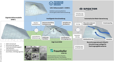
Increasingly severe weather events, driven by climate change, have led to considerable human, ecological, and economic damage. Legal mandates such as the Flood Protection Act II have increased the demand for surface runoff risk assessments, prompting municipalities and planning offices to employ heavy rain hazard maps based on digital elevation models (DEM) generated via airborne laser scanning (ALS). However, the intervals between scans delay updates on urban changes, resulting in incomplete representations of structures that affect runoff simulations. Uncrewed aerial vehicles (UAVs) are now utilized for detailed aerial surveys, yielding cm-precise UAV-based DEMs that are advantageous for densely populated regions. Integrating this data into hydraulic heavy rain simulations proves intricate due to heightened detail, requiring manual feature selection due to hardware and software limitations. Despite the value of UAV data, processing costs hinder widespread adoption. Automatically merging UAV-derived DEMs with existing ALS-based DEMs poses challenges, necessitating techniques for aligning point clouds of varying resolutions.
This project aims to merge both DEM types with a robust method for aligning point clouds and automated integration of UAV-recognized structures, enhancing accuracy and coverage for runoff simulations to provide municipalities with up-to-date, informative heavy rain risk maps.
Partners:
- SPEKTER GmbH
- Fraunhofer Gesellschaft e. V. Institute of Optronics, System Technologies and Image Exploitation (IOSB); Industrial Automation branch (INA) of Fraunhofer IOSB
- TUD Dresden University of Technology; Institute of Photogrammetry and Remote Sensing; Junior Professorship in Geosensor Systems
Funding: This Project is supported by the Federal Ministry for Economic Affairs and Energy (BMWE) on the basis of a decision by the German Bundestag.


