EO2HEAVEN (Earth Observation and Environmental Modelling for the Mitigation of Health Risks)
Titel des Projekts
Earth observation and environmental modelling for the mitigation of health risks
Förderung
EU FP7 Projekt 190301/52
Motivation
Städtische und industrielle Entwicklungen führen zu zahlreichen globalen und lokalen Veränderungen z.B.:
- Anthropogene Veränderungen der Landschaft: Städtische Landnutzungsplanung bewirkt die Abholzung von Waldflächen, Bodenerosion, den Verlust von Mineral- und Spurenelementen, erhöht das Risiko von Naturkatastrophen (Fluten und unkontrollierte Brände), etc.
- Veränderungen durch tägliche Aktivitäten der Bevölkerung: Diese Aktivitäten bewirken Emissionen und Giftmüll, die zur Luftverschmutzung führen. Die Bevölkerung ist diesen Emissionen direkt ausgesetzt, oder sie können indirekt durch die Nahrungskette oder andere komplexe Umweltprozesse betroffen sein.
- Klimawandel: Ist die offensichtliche Folge von Landschaftsveränderungen, die über einen langen Zeitraum anthropogen geprägt wurden.
All diese Veränderungen der Umweltbedingungen haben einen großen Einfluss auf die menschliche Gesundheit. Umweltfaktoren, die im Zusammenhang mit Gesundheitsaspekten betrachtet werden müssen sind Luft-, Meeres- und Wasserverschmutzung, das Ozonloch, schwer abbaubare organische Schadstoffe, Veränderung der räumlichen und zeitlichen Verbreitung von Pollen und anderen Asthma auslösenden Antigenen sowie wetterbedingte Krankheitsüberträger durch Klimawandel. Es ist schwierig das Ausmaß der Gesundheitsprobleme zu quantifizieren, die auf eine Veränderung der genannten Umweltbedingungen zurückzuführen sind. Ein Indiz können aber kardiorespiratorische Krankheiten, Infektionskrankheiten und eine Verkürzung der Lebenserwartung sein. Es existieren viele Umwelt- und Gesundheitsdaten. Jedoch muss der Zusammenhang zwischen beiden noch hergestellt werden.
Ziel des Projekts
EO2HEAVEN soll dazu beitragen die komplexen Zusammenhänge zwischen Umweltveränderungen und ihrer Auswirkung auf die menschliche Gesundheit besser zu verstehen. In dem Projekt werden anthropogene Veränderungen beobachtet, wobei der Schwerpunkt auf atmosphärischer Verschmutzung und auf der Verschmutzung von Flüssen, Seen und Küsten liegt. Um ein nützliches Werkzeug für die Untersuchung der menschlichen Gefährdung und das frühe Erkennen von Infektionen zu schaffen, ist ein weiteres Ziel der Entwurf und die Entwicklung eines GIS, basierend auf einem freien und standard-basierten SII (Spatial Information Infrastructure). Die Schlüsselfaktoren des EO2HEAVEN-Systems werden sein:
- eine verbesserte Integration umweltrelevanter Messwerte von Fernerkundungssensoren und Bodenstationen (in situ Daten)
- die Entwicklung von Modellen für die Verknüpfung dieser Umweltdaten mit Gesundheitsdaten
Während des Projektes werden die Anforderungen von drei verschiedenen Fallstudien (in Europa und Südafrika) abgeschätzt und ihre technischen Umsetzungen iterativ beurteilt mit dem Ziel global anwendbare Lösungsansätze zu entwickeln.
Projektorganisation
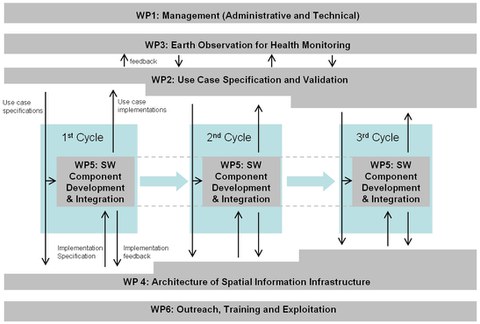
Die Abbildung zeigt das Zusammenspiel der einzelnen EO2HEAVEN Arbeitspakete (WPs) innerhalb der drei Entwicklungszyklen: WP2 definiert und spezifiziert spezielle Anwendungsfälle innerhalb der Fallstudien. In jedem Entwicklungszyklus werden diese Spezifizierungen an WP3 und WP4 übermittelt. WP3 ist verantwortlich für die Entwicklung von Werkzeugen für die Integration von in situ Daten, Fernerkundungsdaten und Simulationsdaten sowie für die Analyse des Zusammenhangs zwischen den Umwelt- und Gesundheitsdaten um geeignete Modelle abzuleiten. WP4 spezifiziert generische Architekturkomponenten, die von WP5 umgesetzt werden. Für Validierungszwecke gibt WP5 ihre Implementierungen zurück an WP2.
Fallstudie für Europa
Einflüsse der Umwelt auf Allergien und kardiovaskuläre Krankheiten in Sachsen, Deutschland
Diese Fallstudie konzentriert sich auf Allergien, Bronchialasthma und kardiovaskuläre Erkrankungen in Zusammenhang mit den Umweltparametern Ozon (Boden und atmosphärisch), Aerosole (PM 0.1, PM 2.5 und PM10), Schwefeldioxid und Stickstoffdioxid, Pollen sowie einer Reihe meteorologischer Bedingungen. Der Zweck dieser Fallstudie ist die Entwicklung eines Warnsystems, so dass durch vorbeugende Messungen Gesundheitsgefährdungen aufgrund umweltbedingter Luftverunreinigungen vermieden werden können.
- Erste Iteration: Hauptaufgaben sind das Zusammentragen und die Vorbereitung der Daten. Danach folgen die Datenfusion und die Datenanalyse für ganz Sachsen. Hierbei liegt der spezielle Fokus auf der Korrelation zwischen Umwelt- und Gesundheitsdaten auf Basis verknüpfter Fernerkundungdaten und in situ Daten.
- Zweite Iteration: Die ersten Ergebnisse der Datenanalyse werden für die Entwicklung der SII herangezogen. Darüberhinaus soll für die Stadt Dresden eine detailliertere Untersuchung der Beziehung zwischen Umwelt und Gesundheit durchgeführt werden, um insbesondere eine höhere räumliche Auflösung zu erzielen. Im Informationssystem werden interaktive und Web-basierte Karten zur Luftqualität als auch Risikokarten für Allergien und kardiovaskuläre Erkrankungen entworfen.
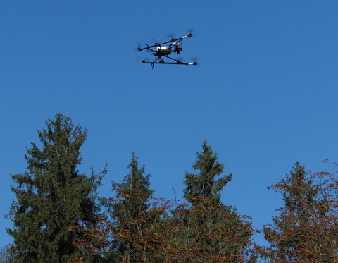
- Dritte Iteration: Für Experten wird ein System zur Anzeige von Gesundheitsrisiken entworfen. Ein Warnsystem wird entwickelt und soll über die aktuelle Gefährdung durch Umwelteinflüsse informieren. Außerdem, soll dieses Bürgern zur Verfügung gestellt werden. Um eine ad hoc Datenaufnahme zu realisieren und räumlich und zeitlich hochaufgelöste Daten zu generieren, wird der Einsatz eines UAV (Unmanned aerial vehicle) geplant und getestet.

UAV "Falcon 8" der AscTec GmbH mit RGB-Kamera

UAV "Falcon 8" der AscTec GmbH mit RGB-Kamera
Projektpartner
-
Fraunhofer Institute for Information and Data Processing IOSB (Germany)
-
Technische Universität Dresden (Germany)
-
52°North Intitiative for Geospatial Open Source Software GmbH (Germany)
-
Atos Origin Sociedad Anonima Espanola (Spain)
-
Spot Image (France)
-
Nev@ntropic (France)
-
European Commission DG JRC (Belgium)
-
Council for Scientific and Industrial Research, Meraka Institute (South Africa)
-
Open Geospatial Consortium (Europe) Limited (United Kingdom)
-
Bureau de Recherches Geologiques et Minieres (France)
-
International Institute for Geo-Information Science and Earth Observation (The Netherlands)
-
University KwaZulu-Natal (South Africa)
Kontakt
- Prof. Dr. habil. Hans-Gerd Maas (Leitung)
- Dipl.-Ing. Nadine Stelling, Dipl.-Ing. Katharina Pech, Dipl.-Geogr. Anette Richter (Bearbeitung)

