Feb 24, 2022
In rock and ice: On the trail of the millimeter

Ankunft der Gruppe im Gebiet der russischen Antarktisstation Molodeshnaya. V.l.n.r.: Karl Heidrich-Meisner (TU Dresden), Sonja Berg (Uni Köln), Ole Bennike (GEUS Kopenhagen), Maria Kappelsberger (TU Dresden), Niklas Leicher und Bernd Wagner (beide Uni Köln).
The mass change of the Antarctic ice sheet leads to uplift of the earth's crust: in order to measure this, Maria Kappelsberger M.Sc. and Karl Heidrich-Meisner, doctoral candidate and geodesy student at the Professorship for Geodetic Earth System Research at the TU Dresden, working on the Antarctic mainland.
Together with four Quaternary geologists from Cologne and Copenhagen, they conducted field work in the Thala Mountains in Enderby Land, East Antarctica, for two weeks starting February 2, 2022.
On February 14, 2022, the group of six scientists was brought back on board the German research icebreaker "Polarstern". In the meantime, "Polarstern" has reached a width on the return journey in the South Atlantic to the destination port of Cape Town (South Africa), which again enables larger bandwidths for satellite communication and thus the transmission of detailed information and photos.

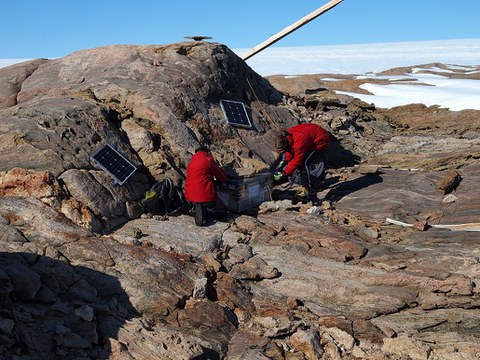
Maria Kappelsberger (links) und Karl Heidrich-Meisner beim Aufbau der GPS-Station Blisnetzow. Die Sicherstellung der Stromversorgung erfolgte mit Hilfe von Solarmodulen.
Maria Kappelsberger and Karl Heidrich-Meisner were able to carry out geodetic GPS measurements for seven to ten days at three specially marked rock points. Deformation rates of the solid earth can be derived from a joint evaluation with the data from the measurement campaigns that have been carried out repeatedly since 2006. The researchers are particularly interested in the vertical deformation rate (or height change), which is most affected by the changes in ice mass. "We hope to achieve an accuracy level of 1 mm/year so that we can also detect small changes," says Dr. Mirko Scheinert, senior scientist at the professorship and head of this project funded by the German Research Foundation (DFG). In order to record the change in ice mass, not only the present must be considered, but one must go back into the past - to about the maximum of the last ice age. In order to explore this climate history of the Holocene (and possibly even further back), the Quaternary geology colleagues drilled sediment cores in various lakes, which are then subjected to detailed analyzes at home.
In the work area, the six scientists were accommodated in a building of the Russian Antarctic station "Molodeshnaya", which was not manned this southern summer. However, they received active support from colleagues at the Belarusian station "Gora Vechernyaya" (German: Abendberg), which is about 15 km away. "The operation to transport the people and scientific equipment from the ship to the work area in the Thala mountains included ten helicopter flights and lasted about ten hours," reports Kappelsberger. Due to the sea ice cover, the "Polarstern" had to move to a position about 35 km from Molodeshnaya. When it was picked up, the sea ice that had broken up and been carried away to the north by wind and currents or had melted allowed an approach of up to approx. 4 km. The two scientists used Skidoos to reach the three GPS measuring points, which are between 1.5 and 18 km away from the Molodeshnaya station. "It was essential that we had good weather conditions and sufficient contrast for a good view," adds Heidrich-Meisner.
The PS128 voyage of the research icebreaker "Polarstern", which ends on February 28, 2022, is the first voyage within the framework of the multidisciplinary joint project "East Antarctic Ice Sheet Instability" (EASI). Mirko Scheinert is a co-applicant in this joint project. "On two subsequent "Polarstern" trips in the southern summer of 2023/2024, further GPS measurements are to be carried out in the peripheral area of East Antarctica, which is difficult to access," reports Scheinert. Above all, however, new geological and geophysical data should be obtained in the transition area between the Antarctic continent and the southern ocean in order to better understand the feedback between the East Antarctic ice sheet, the changing climate conditions, and global sea-level changes.
Contact:
Dr. Mirko Scheinert
Institute of Planetary Geodesy
Chair of Geodetic Earth System Research
Tel.: 0351 463-33683
Links:
- Chair of Geodetic Earth System Research:
https://tu-dresden.de/bu/umwelt/geo/ipg/gef - University of Cologne, Institute of Geology and Mineralogy: https://geologie.uni-koeln.de/arbeitsgruppen/quartaergeologie
- FS „Polarstern“, Alfred-Wegener-Institut Helmholtzzentrum für Polar- und Meeresforschung: https://www.awi.de/expedition/schiffe/polarstern.html, Research ice breaker: https://follow-polarstern.awi.de/
- Belarussian Antarctic Expedition (BAE), Republican Centre for Polar Research, National Academy of Sciences of Belarus: http://belpolus.by/en/
- Russian Antarctic Expedition (RAE), Arctic and Antarctic Research Institute: https://raexp.ru/
- DFG priority programme "Antarctic Ice Areas": https://www.spp-antarktisforschung.de/
