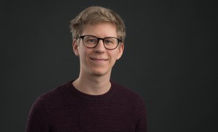
Prof. Dr.-Ing. Ferdinand Maiwald
 © Michael Kretzschmar
Research associate
NameMr Dr.-Ing. Ferdinand Maiwald
Send encrypted email via the SecureMail portal (for TUD external users only).
This website is no longer updated due to the appointment as Professor for Optical 3D-Metrology at TU Dresden!
Curriculum Vitae
- since 04/2024: Professor for Optical 3D-Metrology
- 2017-2022: PhD student at the Chair of Photogrammetry, TU Dresden.
Topic of the thesis: A window to the past through modern urban environments - Developing a photogrammetric workflow for the orientation parameter estimation of historical images Permalink - 2020-2023: research associate at the Chair for Digital Humanities, FSU Jena
- 2016-2024: research associate at the Chair of Photogrammetry, TU Dresden
- 2014-2016: Master's degree in geodesy at the TU Dresden, final thesis on the topic of capturing and analysing three-dimensional deformations on paintings to support the restoration process.
- 2011-2014: Bachelor's degree in geodesy and geoinformation at the TU Dresden, final thesis on the topic of position determination using QR codes
Projects
ongoing
- -
completed
- HistKI: Investigation, Modelling and Multimodal AI-based support of image source research and criticism as a complex and fundamental historical scientific working technique (FSU Jena) (own work completed)
- AIM: Art Information Modeling: Prototype of a Digital Twin for panel paintings
- Jena4D: Virtual city history with citizen participation (FSU Jena)
-
VirtEx: Numerical analysis tool for simulation and risk assessment of climatically and mechanically stressed wooden art objects
- SFB/Transregio 280: Design strategies for material-minimised carbon concrete structures - foundations for a new way of building (own work completed)
- Kulturerbe4D - Digital urban mediation of anthropogenic factors of influence and protective measures on architectural cultural heritage (FSU Jena)
- HistStadt4D: Multimodal access to historical image repositories to support urban and architectural history research and education
Teaching
- Seminar AI in Photogrammetry (Master Geodesy / Geoinformation Technologies)
- Seminar Photogrammetry und Image Analysis (Master Geodesy / Geoinformation Technologies)
- Exercise Robust Estimation Techniques - RANSAC (Master Geodesy / Geoinformation Technologies)
- Geodetic seminar (Bachelor Geodesy)
Awards
- 03/2023 Top Downloaded Author 2021-2022 in The Photogrammetric Record, Wiley
- 02/2023 Top Cited Article 2021-2022 in The Photogrammetric Record, Wiley
- 09/2022 EH Thompson Award
- 05/2019 Best Paper Award - GEORES2019, Milan, Italien
Publications
An error occurred when trying to connect with the FIS.