Projects
Table of contents
Base4NFDI (2023-2028)
Contact:
Lars Bernard
Najla Rettberg
Base4NFDI is establishing a basic service portfolio of cross-cutting services to meet the needs of the scientific community. NFDI-wide basic services can greatly improve efficiency and the seamless and smooth use of research data management services within and outside the National Research Data Infrastructure (NFDI). Base4NFDI involves institutions from all major areas of scientific infrastructure provision and from all major research organizations in Germany. The NFDI-wide basic service portfolio will thus benefit all these communities and domains.
A basic service must be potentially useful for all existing and future consortia. Base4NFDI defines a service as a technical and organizational solution that can include storage and computing services, software, processes and workflows as well as the necessary personnel support for different service desks.
AquaINFRA (2023-2026)
Contact:
Jörg Seegert
The AquaINFRA project aims to develop a virtual environment equipped with FAIR multi-disciplinary data and services to support marine and freshwater scientists and stakeholders restoring healthy oceans, seas, coastal and inland waters. Its virtual environment will enable the target stakeholders to store, share, access, analyse and process research data and other research digital objects from their own discipline, across research infrastructures, disciplines and national borders leveraging on the European Open Science Cloud (EOSC) and the other existing operational dataspaces.
Besides supporting the ongoing development of the EOSC as an overarching research infrastructure, AquaINFRA is addressing the specific need for enabling researchers from the marine and freshwater communities to work and collaborate across those two domains.
TU Dresden is an associated partner in AquaINFRA and our Chair will contribute to several work packages with its expertise – especially in Work Package 6 on Community Engagement and Capacity Building.
KOMET (2023 - 2025)
Contact:
Daniel Nüst
In cooperation with the German National Library of Science and Technology (TIB) Hannover, the project "Collaborative enrichment of the metadata commons to foster a diverse OA ecosystem" (KOMET) promotes the transformation of science towards a diverse and participatory OA culture by supporting independent, oftentimes scholar-led OA journals in professionalising their metadata processes and establishing new cross-disciplinary links between research results based on geospatial metadata, citation metadata, and persistent identifiers.
World Heat Flow Database - WHFD (2022 - 2025)
Contact:
Stephan Mäs
Nikolas Ott
In cooperation with the Geoforschungszentrum (GFZ) Potsdam, the project World Heat Flow Database aims to develop a modern research data infrastructure for global terrestrial heat flow data. Heat flow is a measure of thermal energy flowing from the Earth's core to its surface. As a project partner, TU Dresden is responsible for developing the front-end and online tools for data analysis and visualization for the new web platform.
NFDI4Earth
Contact:
Lars Bernard
Jörg Seegert
NFDI4Earth addresses digital needs of Earth System (ES) Sciences (ESS). ES scientists cooperate in international and interdisciplinary networks with the overarching aim to understand the functioning and interactions within the Earth system and address the multiple challenges of global change. NFDI4Earth is a community-driven process providing researchers with FAIR, coherent, and open access to all relevant ES data, to innovative research data management (RDM) and data science methods.
KlimaKonform (2020-2026)
Contact:
Lars Bernard
Stephan Mäs
Simeon Wetzel
Together with counties and selected sample municipalities, the project will develop an integrative and action-oriented approach for the identification and assessment of climate change adaptation capacities for low mountain regions and prepare it in stakeholder-differentiated decision support tools (DSS) for direct use in planning and decision-making practice.
project website
Weiterentwicklung des Daseinsvorsorgeatlas Niedersachsen (2019 – 2023)
Contact:
Stephan Mäs
Falko Krügel
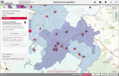
Das Projekt hat das Ziel den existierenden Daseinsvorsorgeatlas Niedersachsen in seiner Funktionalität zu einem multikriteriellen Entscheidungsunterstützungswerkzeug für verschiedene Planungsebenen und -bereiche zu erweitern. Es wird vom Land Niedersachsen durch das Ministerium für Bundes- und Europaangelegenheiten und Regionale Entwicklung und dem Ministerium für Inneres und Sport gefördert.
project website
Finished Projects
- SENSOr (2020-2023)
Contact:
Lars Bernard
The interdisciplinary project "SENSOr - Smart Energy Smart Schools" addresses the question of how the topics of energy and energy transition can be experienced by the school community through the possibilities of digitalisation and within the framework of a holistic education and made visible using the example of the school building. In interdisciplinary, activity-oriented project weeks, the students gain insights into the topics of energy, energy efficiency, energy transition and the possibilities of sensor-based data collection in the school building.
Homepage: https://sensor.geo.tu-dresden.de/
- GeoKur (2019-2022)
Contact:
Lars Bernard
Arne Rümmler
Christin Henzen
Heiko Figgemeier
The BMBF project GeoKur aims to support the curation and quality assurance of environmental data already during the research process, throughout the whole life cycle of the data.
Therefore, existing standards and best practices are evaluated and integrated and finally tested and implemented in a comprehensive proof-of-concept using the example of global land-use dynamics data.
Homepage: https://geokur.geo.tu-dresden.de/
- mVIZ (2019-2020)
Contact:
Stephan Mäs
Laura Zepner
Christin Henzen
mVIZ zielt auf die nutzerfreundliche Visualisierung offener raumzeitlicher Daten. Dazu soll in einer Vorstudie eine Methodik entwickelt werden, die die Auswahl und Erstellung nutzerfreundlicher Visualisierungen für offene raumzeitliche Daten der mCLOUD mit Fokus auf Usability und Nachnutzung unterstützt.
project website
- Technische Umsetzung der geplanten Rechtsänderung für den Vertrieb digitaler Daten (2019)
Contact:
Christin Henzen
Stephan Mäs
Im Auftrag des Staatsbetrieb Geobasisinformation und Vermessung (GeoSN) ist eine Plattform für offene Geobasisdaten zu konzipieren und implementieren. Dazu werden im Projekt sowohl bestehende Produkte und Konfektionierungen, Erstellungsprozesse und Infrastrukturkomponenten strukturiert erfasst und darauf aufbauend Design, Struktur und Architektur der Zielplattform entwickelt.
- SmartRain (2018-2019)
Contact:
Pierre Karrasch
Aufbau eines Monitoring-Netzwerks für lokale Niederschlagsmessungen in der Landeshauptstadt Dresden
more information
- Geoprocessing Appstore
Contact:
Christin Henzen
Daniel Henzen
The Geoprocessing Appstore is a web-based platform for the exchange of algorithms for the processing of geospatial data.
- EXTRUSO (2016-2019)
Contact:
Lars Bernard
Stefan Wiemann
The ESF research group EXTRUSO (extreme events in small and medium catchments) is a cooperation between the chairs of hydrology, meteorology, photogrammetry and geoinformatics. The aims of the project are 1) to obtain comprehensive knowlegde on the development of hydro-meteorological extreme events, 2) the enhancment of hydro-meteorological event prediction and 3) the development of a collaborative information and early warning infrastructure.
more information
- COLABIS (2015-2018)
Contact:
Lars Bernard
Daniel Henzen
Stephan Mäs
The near realtime availability of data has a significant impact on the effectiveness of early warning systems. The integration of the most heterogeneous data streams from different sources to decision-relevant information is still a major challenge in the context of early warning systems. The COLABIS project (Collaborative Early Warning Information Systems for Urban Infrastructures) aims to design and develop a web-based platform, which facilitates the development of urban monitoring and early warning systems by fusing environmental data, simulation results, official, historical and crowdsourced data into a common information platform.
more information
- BOOT (2015-2018)
Contact:
Lars Bernard
Pierre Karrasch
In dem Projekt BOOT-Monitoring wird ein bootgestütztes Messsystem entwickelt, das zur Befahrung kleiner Mittelgebirgs- und Tieflandgewässer genutzt werden kann. Dieses wird modular aufgebaut, um es an die unterschiedlichsten Anforderungen, die sich aus den Fließgewässercharakteristika ergeben, anpassen zu können. Durch die Zusammenarbeit von Projektpartnern aus Sachsen und aus Mecklenburg-Vorpommern können raumbezogene Daten in unterschiedlichen Natur- und Siedlungsräumen ermittelt werden.
Homepage: https://bmbf.nawam-rewam.de/projekt/boot-monitoring/
- Urban Geosensor Networks (2013-2015)
Contact:
Pierre Karrasch
Within the project Urban Geosensor Networks new methods for the fusion of different innovative low-cost sensor and crowdsourcing techniques with conventional measuring systems for the urban environmental monitoring (e.g. air pollution, heat island) are supposed to be developed and field-tested. Furthermore, appropriate extensions for spatial data infrastructures should be designed and implemented.
- GLUES (2010-2017)
Contact:
Lars Bernard
Stephan Mäs
GLUES serves the scientific coordination and synthesis of joint research projects in the BMBF programme "Sustainable Land Use Management". GLUES will establish a consistent data pool for land use dynamics and develop integrated and constistent scenarios for future land use estimation at different spatial and temporal scales. The GIS professorship coordinates the establishment of a Spatial Data Infrastructure that helps to implement these objectives.
Homepage: http://nachhaltiges-landmanagement.de
- COBWEB (2013-2017)
Contact:
Lars Bernard
Stefan Wiemann
The COBWEB project aims at the creation of an online-information systems for collaborative collection and analysis of data from UNESCO Biospere Reserves. It will incorporate the collection of data via mobile devices, quality assurance as well as the aggregation with Spatial Data Infrastructures as reference daat from authorative sources.
Homepage:
https://cobwebproject.eu
- Geographic information: Need to Know (2013-2016)
Contact:
Lars Bernard
The project GI-N2K (Geographic information: Need to Know, Funded by the EU Erasmus Lifelong Learning Program) aims to improve the way in which future GI professionals are prepared for the labor market. The project will analyze the current market demands with regard to the knowledge and skills and compare them with the current training offer in the GI S&T sector. GI-N2K builds upon the existing Geographic Information Science and Technology Body of Knowledge (GI S&T BoK) that was developed by the American University Consortium for Geographic Information Science, published in 2006 by the Association of American Geographers. The existing GI S&T Body of Knowledge will be used as a starting point, updated and brought in line with new technological developments, and with the European perspective in mind.
Homepage:
http://www.gi-n2k.eu
- ANTI-Resist (2011 - 2014)
ANTI-Resist will reseach the release of antibiotics to urban sewange systems and the develoment of antibiotic resistances using the example of the city of Dresden. The aim of the project is to design strategies to reduce the release of antibiotics and to develop corresponding monitoring and warning systems.
Homepage:
http://antiresist.dyndns.org/
- LANIS (2013 - 2014)
Contact:
Lars Bernard
Stephan Mäs
Stefan Wiemann
Studie zur Evaluation und zu mittelfristigen Strategien für das Landschaftsinformationssystem (LANIS) der Naturschutzverwaltung in Rheinland-Pfalz.
Link zur Studie
- EO2HEAVEN (2010 - 2013)
Contact:
Stefan Wiemann
EO2HEAVEN will develop a better understanding of the complex relationships between environmental factors, population exposure, and health impacts. These correlations will be studied in three use cases. They are located in different geographical regions (South Africa, Mozambique, Germany) and focus on different topics (air pollution, vector-borne infectious disease).
Homepage:
http://www.eo2heaven.org
- GDI Sachsen (2008)
Since the beginning of 2005 Saxony has a web-application to use geographical information systems in schools. This WebGIS-application is integrated in the Saxon Education Server. Therefore the service is available for all schools and can be applied in education and school projects. The aim of this project is to develop the web-application of the Saxon Education Server further, to use newest technologies and to integrate it in the spatial data infrastructure of Saxony. The so-called WebGIS should be positioned as a practical SDI-application in publicity.
- Pilot study for an operational concept for the SDI Saxony (2008)
Initiated by the Ministry of the Interior of the Free State of Saxony we carried out a pilot study for the operational concept for the SDI Saxony. The pilot study covers business processes to offer geospatial data, its meta data and corresponding web services, as well as its eGovernment models. Technical components of the SDI Saxony and potential topologies of this components are described. The resulting suggestions to realise an operational SDI Saxony in the Free State provide the fundamentals for a successul Saxon INSPIRE implementation in a close relation to the federal German SDI initiative 'GDI-DE'.
- GIGAS (2008 - 2010)
The GEOSS, INSPIRE and GMES an Action in Support The GIGAS promotes the coherent and interoperable development of the GMES, INSPIRE und GEOSS initiatives. It will contribute to the emergence of a collaborative information space for accessing and sharing distributed environmental resources in Europe.
Homepage:
http://www.thegigasforum.eu
- HEREPLUS (2008 - 2011)
The EU research project HEalth Risk from Environmental Pollution Levels in Urban Systems (Hereplus) investigates the correlation between air pollution (PM10 and ozone) and the impacts on the health of human being in urban areas. The cities selected are Dresden, Rom, Madrid and Athen.
- OWS-8: WPS für die Analyse von Fernerkundungsdaten (2010)
OWS testbeds are part of the Open Geospatial Consortium's Interoperability Program; they are collaborative efforts to define, design, develop, and test candidate interface and encoding specifications. For OWS Phase 8 a set of data analysis algorithms has been developed to identify anomailies in plant growth in the amazon region. These algorithms have been tuned for mass data processing.
Homepage:
OWS-8
- LPIS (2010)
Within the context of the Common Agricultural Policy of the European Union a SDI approach for its geographical module, the Land Parcel Identification System, was discussed. Therefore Test Bed services for schema transformation and data validation were prototypically implemented.
- SoKNOS (2007 - 2009)
The aim of this project is to develop effective concepts that support the bodies of public safety like police and fire brigade. The focus of the project is the organization and optimization of information flow in the case of major loss occurrences. Through this a more effective acting of the participating emergency services will be guaranteed. The solutions shall make a long-term contribution to the public safety. The implementation is realized as a service-oriented infrastructure in order to fulfill the major demands ease-of-use, interoperability, safety and stability. The project is supported by the Federal Ministry of Education and Research.

