AutoDrone - Use of autonomously operated drone technology in forest inventory
AutoDrone - Use of autonomously operated drone technology in forest inventory
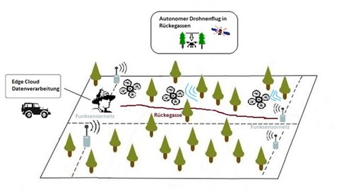
Development of a control technology for drones with the aim of autonomous drone flight on or over machine paths, back roads, forest tracks and similar line structures within forest stands. The available free space profile above the line structures is used as flight space. By an appropriate flight altitude, structure path edges close to the ground are neglected, which in terrestrial procedures exclude a valid recording of the tree parameters inside the stand due to the visual obstruction. The control system is to be based on fused WSN, inertial and GNSS signals and at the same time digitize the flight routes by radar during the flight.

AutoDrone
Tasks ITVS:
- Compensation of weak or non-existent GNSS signals in a forest environment by using radio sensor networks
- Automatic flight stabilization with regard to altitude and the required lateral positioning over the forest floor
- Multisensor data fusion and position filter algorithms for autonomous flight primarily based on a radio sensor network and secondarily based on an imaging position module
- Use of a radio sensor system for communication, location and environment detection of drones
- Adaptation/further development of visioning position modules for the forest environment regarding obstacle detection of trees, branches, bushes and segmentation of the forest floor as well as a constant flight altitude
- Implementation of a Simultaneous Localization and Mapping (SLAM) algorithm for autonomous flight within a geofence of the return path
Project partners:
- Trans4mation IT GmbH (www.trans4mation.de)
- TU Dresden; Institut für Verkehrstelematik (www.tu-dresden.de/vkw/itvs)
Duration: 11/2020 - 10/2022
Sponsor: Fachagentur für Nachwachsende Rohstoffe e.V.
Contact: Robert Richter
